
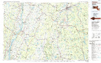
~ Pittsfield MA topo map, 1:100000 scale, 30 X 60 Minute, Historical, 1986, updated 1986
Pittsfield, Massachusetts, USGS topographic map dated 1986.
Includes geographic coordinates (latitude and longitude). This topographic map is suitable for hiking, camping, and exploring, or framing it as a wall map.
Printed on-demand using high resolution imagery, on heavy weight and acid free paper, or alternatively on a variety of synthetic materials.
Topos available on paper, Waterproof, Poly, or Tyvek. Usually shipping rolled, unless combined with other folded maps in one order.
- Product Number: USGS-5636105
- Free digital map download (high-resolution, GeoPDF): Pittsfield, Massachusetts (file size: 23 MB)
- Map Size: please refer to the dimensions of the GeoPDF map above
- Weight (paper map): ca. 55 grams
- Map Type: POD USGS Topographic Map
- Map Series: HTMC
- Map Verison: Historical
- Cell ID: 72650
- Scan ID: 353175
- Imprint Year: 1986
- Woodland Tint: Yes
- Aerial Photo Year: 1978
- Edit Year: 1986
- Datum: NAD27
- Map Projection: Universal Transverse Mercator
- Planimetric: Yes
- Map published by United States Geological Survey
- Map Language: English
- Scanner Resolution: 600 dpi
- Map Cell Name: Pittsfield
- Grid size: 30 X 60 Minute
- Date on map: 1986
- Map Scale: 1:100000
- Geographical region: Massachusetts, United States
Neighboring Maps:
All neighboring USGS topo maps are available for sale online at a variety of scales.
Spatial coverage:
Topo map Pittsfield, Massachusetts, covers the geographical area associated the following places:
- Paradise Hill - Rossman - Rayville - Valatie - Camp Romaca - Claverack - Hollowville Trailer Park - Flatbrook - Adams Junction - Copake - Cairo Junction - Hartsville - Feddes Mobile Home Park - Greenport Center - Lawrenceville - Dutch Village Mobile Home Park - East Taghkanic - Otis - West Becket - Chatham - Stevens Corner - South Cairo - College Park - Ancram - Camp Mah-Kee-Nac - Yankee Orchards - Camp Chimney Corners - Canaan - Mahkeenac Heights - Bingham Mills - Taconic Shores - Berkshire Heights - Surprise - East Sheffield - Red Rock - Monterey - Crane Lake Camp - Stuyvesant Falls - North Hillsdale - Camp Emerson - Canoe Hill - Brick Tavern - Dalton - Copake Lake - Algerie Four Corners - East Greenville - Spencertown - Viewmonte - Whitehouse Crossing - Newton Hook - West Otis - Schodack Landing - Van Deusenville - Hollowville - Alander - Canaan Center - Spaulding Furnace - Aquetuck - Livingston - Camp Jayson - Burvey Mobile Home Park - Saugerties - South Sandisfield - Camp Marion White - Hamburg - Ravena - West Ghent - Roberts Hill - Coeymans - Mount Ross - Boston Corner - Upper Hollowville - West Norfolk - New Marlborough - Result - Camp Russell - Malden Bridge - Smith Landing - Muitzes Kill - Sandisfield - Hudson - West Camp - Taghkanic - Camp Kingsmont - Glenco Mills - East Chatham - Clermont - Alcove - Dormansville - East Lee - Germantown - Greendale - Stottville - Roah Hook - Tolland Center - Katsbaan - Albrights - Green River - Annandale-on-Hudson - Craryville
- Map Area ID: AREA42.542-74-73
- Northwest corner Lat/Long code: USGSNW42.5-74
- Northeast corner Lat/Long code: USGSNE42.5-73
- Southwest corner Lat/Long code: USGSSW42-74
- Southeast corner Lat/Long code: USGSSE42-73
- Northern map edge Latitude: 42.5
- Southern map edge Latitude: 42
- Western map edge Longitude: -74
- Eastern map edge Longitude: -73


