
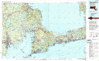
~ New Bedford MA topo map, 1:100000 scale, 30 X 60 Minute, Historical, 1994, updated 1994
New Bedford, Massachusetts, USGS topographic map dated 1994.
Includes geographic coordinates (latitude and longitude). This topographic map is suitable for hiking, camping, and exploring, or framing it as a wall map.
Printed on-demand using high resolution imagery, on heavy weight and acid free paper, or alternatively on a variety of synthetic materials.
Topos available on paper, Waterproof, Poly, or Tyvek. Usually shipping rolled, unless combined with other folded maps in one order.
- Product Number: USGS-5636103
- Free digital map download (high-resolution, GeoPDF): New Bedford, Massachusetts (file size: 31 MB)
- Map Size: please refer to the dimensions of the GeoPDF map above
- Weight (paper map): ca. 55 grams
- Map Type: POD USGS Topographic Map
- Map Series: HTMC
- Map Verison: Historical
- Cell ID: 68038
- Scan ID: 353169
- Imprint Year: 1994
- Woodland Tint: Yes
- Aerial Photo Year: 1970
- Edit Year: 1994
- Datum: NAD27
- Map Projection: Universal Transverse Mercator
- Map published by United States Geological Survey
- Map Language: English
- Scanner Resolution: 600 dpi
- Map Cell Name: New Bedford
- Grid size: 30 X 60 Minute
- Date on map: 1994
- Map Scale: 1:100000
- Geographical region: Massachusetts, United States
Neighboring Maps:
All neighboring USGS topo maps are available for sale online at a variety of scales.
Spatial coverage:
Topo map New Bedford, Massachusetts, covers the geographical area associated the following places:
- South Dartmouth - Bourne - Hatchville - Nonquitt - Fairhaven - North Fairhaven - East Marion - South Harwich - Plainville - Camp Burgess - North Carver - Manomet Heights - Cannonville - Cooks Brook Beach - Cedar Bushes - Acushnet - Maushop Village - Wareham Center - Pocasset - Gray Gables - Water View Village - Racing Beach - Staples Shore - Long Plain - Oyster Harbors - Falmouth Heights - Sandwich - Apponagansett - Wolf Lake - North Rochester - Five Corners - Bliss Corner - Ashley Heights - West Yarmouth - Pine Bluffs - Namasket Village - East Falmouth - Plympton - Cataumet - Pondsville - Beach Park - Camp Mar Vel (historical) - South Chatham - Churchill Landing - Canedys Corner - South Truro - Plymouth Mobile Estates - Acushnet Station (historical) - Alms House - Popponesset - Fuller Shores - Davisville - Grand Vue - Staples Corner - Bourne Corners - Rocky Nook Point - Harwich - Waterville - Carver - North Dennis - Barlows Landing - Truro - Cummaquid - Bisbee Corner - Wareham - Lakeview Heights - Lakeside - Menauhant - Rochester - Marion - Oxford - Dennis - Lakeside Shore - Knollmere - Falmouth - Teaticket - Jefferson Shores - East Dennis - New Boston - Rockdale - Monomoscoy Island - Seconsett Island - Buzzards Bay - Rock Harbor - Maxim Corner - Osterville - Inland Park - Camp Mishannock - South Dennis - Huckleberry Shores - Yarmouth Port - Prospect Hill - East Fairhaven - Nelsons Shores - Kingston Shores - Woods Hole - Sampsons Corner - Harbor Beach - Rocky Nook - Oakdale
- Map Area ID: AREA4241.5-71-70
- Northwest corner Lat/Long code: USGSNW42-71
- Northeast corner Lat/Long code: USGSNE42-70
- Southwest corner Lat/Long code: USGSSW41.5-71
- Southeast corner Lat/Long code: USGSSE41.5-70
- Northern map edge Latitude: 42
- Southern map edge Latitude: 41.5
- Western map edge Longitude: -71
- Eastern map edge Longitude: -70


