
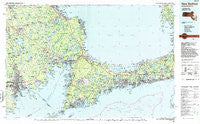
~ New Bedford MA topo map, 1:100000 scale, 30 X 60 Minute, Historical, 1986, updated 1986
New Bedford, Massachusetts, USGS topographic map dated 1986.
Includes geographic coordinates (latitude and longitude). This topographic map is suitable for hiking, camping, and exploring, or framing it as a wall map.
Printed on-demand using high resolution imagery, on heavy weight and acid free paper, or alternatively on a variety of synthetic materials.
Topos available on paper, Waterproof, Poly, or Tyvek. Usually shipping rolled, unless combined with other folded maps in one order.
- Product Number: USGS-5636101
- Free digital map download (high-resolution, GeoPDF): New Bedford, Massachusetts (file size: 33 MB)
- Map Size: please refer to the dimensions of the GeoPDF map above
- Weight (paper map): ca. 55 grams
- Map Type: POD USGS Topographic Map
- Map Series: HTMC
- Map Verison: Historical
- Cell ID: 68038
- Scan ID: 353168
- Imprint Year: 1986
- Woodland Tint: Yes
- Aerial Photo Year: 1982
- Edit Year: 1986
- Datum: NAD27
- Map Projection: Universal Transverse Mercator
- Planimetric: Yes
- Map published by United States Geological Survey
- Map Language: English
- Scanner Resolution: 600 dpi
- Map Cell Name: New Bedford
- Grid size: 30 X 60 Minute
- Date on map: 1986
- Map Scale: 1:100000
- Geographical region: Massachusetts, United States
Neighboring Maps:
All neighboring USGS topo maps are available for sale online at a variety of scales.
Spatial coverage:
Topo map New Bedford, Massachusetts, covers the geographical area associated the following places:
- East Fairhaven - Sandwich - Camp Norse - South Halifax - North Dartmouth - Sunken Meadow Beach - Maxim Corner - Coury Heights - Redgate Corner - East Sandwich - Barlows Landing - Antassawamock - Inland Park - Patuxet (historical) - Halifax Mobile Home Estates - Plympton - Harrubs Corner - Mattapoisett - Newtown - Camp Edwards - North Middleboro - Osterville - Truro - Pondsville - Seabrook - Nasketucket - Hyannis Port - Douglas Corner - Lakeside - Camp Burgess - Cedarville - New Bedford - Rocky Nook Park - Great Neck - Camp Avoda - Huckleberry Corner - Bliss Corner - Shutleff Corner - Grand Vue - Sagamore Highlands - Tinkhamtown - Long Plain - Smalltown - Mashpee - Old Silver Beach - Holly Woods - Wareham Center - Cotuit - Onset Station - West Brewster - Halfway Pond - East Falmouth - Harbor View - Wenham - Truro Station (historical) - North Rochester - Sippewisset - Winsegansett Heights - Scorton Shores - Camp Mar Vel (historical) - Plymouth Mobile Estates - Monument Beach - Alms House - Westgate Park - Chiltonville - Canedys Corner - Bass River - East Dennis - West Falmouth - Jefferson Shores - Crescent Beach - Yarmouth - Pinehurst Mobile Home Village - South Yarmouth - Saconesset Hills - Weweantic - Quissett - Bourne Corners - Old Quaker Meetinghouse - Pine Hill Acres - Rock Harbor - Namasket Village - Macomber Corner - Acushnet - Staples Corner - Manomet Bluffs - Mashpee Neck - Smith Mills - Pine Tree Corner - West Hyannisport - West Barnstable - Hyannis - Pondville - Pocasset Station - Maushop Village - Rock - Sturtevant Mill - Kingdom Hall - Braleys - Pine Haven
- Map Area ID: AREA4241.5-71-70
- Northwest corner Lat/Long code: USGSNW42-71
- Northeast corner Lat/Long code: USGSNE42-70
- Southwest corner Lat/Long code: USGSSW41.5-71
- Southeast corner Lat/Long code: USGSSE41.5-70
- Northern map edge Latitude: 42
- Southern map edge Latitude: 41.5
- Western map edge Longitude: -71
- Eastern map edge Longitude: -70


