
~ Lowell MA topo map, 1:100000 scale, 30 X 60 Minute, Historical, 1988, updated 1988
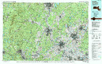
Lowell, Massachusetts, USGS topographic map dated 1988.
Includes geographic coordinates (latitude and longitude). This topographic map is suitable for hiking, camping, and exploring, or framing it as a wall map.
Printed on-demand using high resolution imagery, on heavy weight and acid free paper, or alternatively on a variety of synthetic materials.
Topos available on paper, Waterproof, Poly, or Tyvek. Usually shipping rolled, unless combined with other folded maps in one order.
- Product Number: USGS-5636091
- Free digital map download (high-resolution, GeoPDF): Lowell, Massachusetts (file size: 40 MB)
- Map Size: please refer to the dimensions of the GeoPDF map above
- Weight (paper map): ca. 55 grams
- Map Type: POD USGS Topographic Map
- Map Series: HTMC
- Map Verison: Historical
- Cell ID: 67876
- Scan ID: 353165
- Imprint Year: 1988
- Woodland Tint: Yes
- Aerial Photo Year: 1985
- Edit Year: 1988
- Datum: NAD27
- Map Projection: Universal Transverse Mercator
- Map published by United States Geological Survey
- Map Language: English
- Scanner Resolution: 600 dpi
- Map Cell Name: Lowell
- Grid size: 30 X 60 Minute
- Date on map: 1988
- Map Scale: 1:100000
- Geographical region: Massachusetts, United States
Neighboring Maps:
All neighboring USGS topo maps are available for sale online at a variety of scales.
Spatial coverage:
Topo map Lowell, Massachusetts, covers the geographical area associated the following places:
- Vose - Parkerville - Pingryville - West Derry - South Lynnfield - Leominster - Brentwood - North Woburn - Burtts Crossing - Shawsheen Heights - East Parish - Salem Depot - Princeton Village - Wamesit - Mountain Base - The Pines - MacDowell Colony - Marshall Corner - West Chelmsford - Brookside Station - Noone - Wellville - Fox Hill - Wilton - Newton - Marble Ridge Station - Howards Grove - West Kingston - Westville - Woodsville - Atkinson Heights - High Bridge - Centre Village (historical) - Suttons Mills - East Merrimack - Highlandville - Shirley Center - Gardner - West Leominster - Billerica - Belvidere - West Hampstead - Reading Highlands - East Gardner - Tozier Corner - Ayers Village - Highlands - Rogersville (historical) - Brigadoon Village - South Row - South Ashburnham - Lunenburg Station - Collinsville - Shirley - Ashby - Lowell Junction - Sargent Corners - Goffs Falls - North Reading - Harvard Station - South Middleton - Nashua - Hayward Corner - Fremont - Ashburnham - North Leominster - South Milford - Lakewood Park - Wachusett - Hudson - North Chelmsford - Elmwood - South Fitchburg - North Pepperell - Townsend Harbor - Silver Lake - Varnumtown - Derry Village - Drury - Hollis - Bradford - Bleachery - Thorntons Ferry - Middlesex Village - Windham - Cluffs Crossing - South Merrimack - Plaistow - Perham Corner - Squantum - Chester - Highlands - Wilmington Junction - Crane Crossing - Stevens Crossing - North Billerica - Camp Massapoag - Wilder - Whitmanville - Wilson
- Map Area ID: AREA4342.5-72-71
- Northwest corner Lat/Long code: USGSNW43-72
- Northeast corner Lat/Long code: USGSNE43-71
- Southwest corner Lat/Long code: USGSSW42.5-72
- Southeast corner Lat/Long code: USGSSE42.5-71
- Northern map edge Latitude: 43
- Southern map edge Latitude: 42.5
- Western map edge Longitude: -72
- Eastern map edge Longitude: -71


