
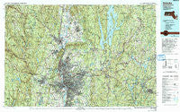
~ Holyoke MA topo map, 1:100000 scale, 30 X 60 Minute, Historical, 1985, updated 1993
Holyoke, Massachusetts, USGS topographic map dated 1985.
Includes geographic coordinates (latitude and longitude). This topographic map is suitable for hiking, camping, and exploring, or framing it as a wall map.
Printed on-demand using high resolution imagery, on heavy weight and acid free paper, or alternatively on a variety of synthetic materials.
Topos available on paper, Waterproof, Poly, or Tyvek. Usually shipping rolled, unless combined with other folded maps in one order.
- Product Number: USGS-5636089
- Free digital map download (high-resolution, GeoPDF): Holyoke, Massachusetts (file size: 42 MB)
- Map Size: please refer to the dimensions of the GeoPDF map above
- Weight (paper map): ca. 55 grams
- Map Type: POD USGS Topographic Map
- Map Series: HTMC
- Map Verison: Historical
- Cell ID: 67677
- Scan ID: 353164
- Imprint Year: 1993
- Woodland Tint: Yes
- Photo Inspection Year: 1989
- Aerial Photo Year: 1983
- Edit Year: 1985
- Datum: NAD27
- Map Projection: Universal Transverse Mercator
- Map published by United States Geological Survey
- Map Language: English
- Scanner Resolution: 600 dpi
- Map Cell Name: Holyoke
- Grid size: 30 X 60 Minute
- Date on map: 1985
- Map Scale: 1:100000
- Geographical region: Massachusetts, United States
Neighboring Maps:
All neighboring USGS topo maps are available for sale online at a variety of scales.
Spatial coverage:
Topo map Holyoke, Massachusetts, covers the geographical area associated the following places:
- Bisbee Mill - Gilbertville - Mundale - Great Swamp - North Wilbraham - Sturbridge - Oakdale - Bay State - Freeman Knoll - East Whately - Mashapaug - West Agawam - Russellville - North Farms - Norwich - Camp Howe - Fiskdale - Globe Village - Amherst Center - Smith Highlands - Three Rivers - Dudleyville - Mountain Park - Smithville - Ludlow - Brightside - Meadowbrook Green - South Spencer - Mystic Grove - Mileoak Corner - Mill Valley - South Quabbin Villa - North Brookfield - Littleville - West Granville - Florence - Brush Hill Mobile Home Park - Mathies Manor - Gillett Corner - Belchertown - Old Sturbridge Village - Highland Glen Estates - Williamsburg Station - Moody Corner - North Agawam - Wyben - Longmeadow - Little River - Laurel Park - Owen District - Butlerville - Forest Park - Riverdale - Prescott Center - Springfield - Shaker Pines - Palmer - Granville - Packardville - South Hadley Falls - Pratt Corner - Cooleyville - Congamond - Liberty Heights - South End - West Farms - North Thompsonville - South Amherst - Hampton Ponds - Baconville - Shutesbury - South Factory Village - Fairview - Chesterfield - West Springfield - Cushman - Wales - West Ware - Hatfield - Woronoco Heights - Hadley - East Farms - Dana Center - Worthington Corners - Granville Center - North Chicopee - Smiths Ferry - Goss Heights - Nonatomqua Mobile Home Park - North Prescott - North Chester - Cayenne - White Valley - Smiths (historical) - Wheelwright - Bryant Four Corners - Baptist Village - North Blandford - Mount Tom - Sixteen Acres
- Map Area ID: AREA42.542-73-72
- Northwest corner Lat/Long code: USGSNW42.5-73
- Northeast corner Lat/Long code: USGSNE42.5-72
- Southwest corner Lat/Long code: USGSSW42-73
- Southeast corner Lat/Long code: USGSSE42-72
- Northern map edge Latitude: 42.5
- Southern map edge Latitude: 42
- Western map edge Longitude: -73
- Eastern map edge Longitude: -72


