
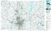
~ Holyoke MA topo map, 1:100000 scale, 30 X 60 Minute, Historical, 1985, updated 1986
Holyoke, Massachusetts, USGS topographic map dated 1985.
Includes geographic coordinates (latitude and longitude). This topographic map is suitable for hiking, camping, and exploring, or framing it as a wall map.
Printed on-demand using high resolution imagery, on heavy weight and acid free paper, or alternatively on a variety of synthetic materials.
Topos available on paper, Waterproof, Poly, or Tyvek. Usually shipping rolled, unless combined with other folded maps in one order.
- Product Number: USGS-5636087
- Free digital map download (high-resolution, GeoPDF): Holyoke, Massachusetts (file size: 26 MB)
- Map Size: please refer to the dimensions of the GeoPDF map above
- Weight (paper map): ca. 55 grams
- Map Type: POD USGS Topographic Map
- Map Series: HTMC
- Map Verison: Historical
- Cell ID: 67677
- Scan ID: 353163
- Imprint Year: 1986
- Aerial Photo Year: 1983
- Edit Year: 1985
- Datum: NAD27
- Map Projection: Universal Transverse Mercator
- Planimetric: Yes
- Map published by United States Geological Survey
- Map Language: English
- Scanner Resolution: 600 dpi
- Map Cell Name: Holyoke
- Grid size: 30 X 60 Minute
- Date on map: 1985
- Map Scale: 1:100000
- Geographical region: Massachusetts, United States
Neighboring Maps:
All neighboring USGS topo maps are available for sale online at a variety of scales.
Spatial coverage:
Topo map Holyoke, Massachusetts, covers the geographical area associated the following places:
- East Brookfield - Smithville - Pine Grove - Loudville - South Quabbin Villa - Cooleyville - Ringville - Goss Heights - Moody Corner - Greenwich (historical) - Meads Corner - Swift River - Tenneyville - Johnson Corner - Bradstreet - McKnight and Bay - Sunderland - Pine Point - North Monson - Wilbraham - Mill Village - West Brimfield - Chicopee - Camp Berkshire - Dana Center - Plainville (historical) - Moores Corner - Westhampton - Baconville - Petersham - Smiths Ferry - Baird Four Corners - North Amherst - Furnace - Mittineague - North Hatfield - Duncan Knoll - New Braintree - Vining Hill - Camp Howe - West Warren - Fairview - West Worthington - Chesterfield - East Hadley - Holland - Easthampton - Florence - Woronoco Heights - Ingleside - Swanson Corners - North Chicopee - West Chesterfield - Palmer Center - Holyoke - West Springfield - East Leverett - Littleville - Smiths (historical) - East Whately - Hampden - Indian Orchard - Cummington - Sandersdale - Amherst - Rising Corner - Worthington Center - Trainfield - Hardwick - Southbridge - Aldrich Mills - South Hadley - Ashleyville - East Windsor - Cadys Corners - Tatham - West Pelham - Halladay Corner - Williamsville - North Brookfield - Globe Village - Springfield Hill - Springdale - Northampton - Duckville - Mathies Manor - Highland Park - Old Sturbridge Village - Brightwood - South Factory Village - Sixteen Acres - North End - Ebbs Corner - Ludlow City - Paucatuck (historical) - North Agawam - Congamond - Gilbertville - Shaker Pines - Perry Manor
- Map Area ID: AREA42.542-73-72
- Northwest corner Lat/Long code: USGSNW42.5-73
- Northeast corner Lat/Long code: USGSNE42.5-72
- Southwest corner Lat/Long code: USGSSW42-73
- Southeast corner Lat/Long code: USGSSE42-72
- Northern map edge Latitude: 42.5
- Southern map edge Latitude: 42
- Western map edge Longitude: -73
- Eastern map edge Longitude: -72


