
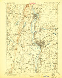
~ Springfield MA topo map, 1:62500 scale, 15 X 15 Minute, Historical, 1895
Springfield, Massachusetts, USGS topographic map dated 1895.
Includes geographic coordinates (latitude and longitude). This topographic map is suitable for hiking, camping, and exploring, or framing it as a wall map.
Printed on-demand using high resolution imagery, on heavy weight and acid free paper, or alternatively on a variety of synthetic materials.
Topos available on paper, Waterproof, Poly, or Tyvek. Usually shipping rolled, unless combined with other folded maps in one order.
- Product Number: USGS-5635943
- Free digital map download (high-resolution, GeoPDF): Springfield, Massachusetts (file size: 7 MB)
- Map Size: please refer to the dimensions of the GeoPDF map above
- Weight (paper map): ca. 55 grams
- Map Type: POD USGS Topographic Map
- Map Series: HTMC
- Map Verison: Historical
- Cell ID: 62875
- Scan ID: 353052
- Survey Year: 1887
- Datum: Unstated
- Map Projection: Unstated
- Map published by United States Geological Survey
- Map Language: English
- Scanner Resolution: 600 dpi
- Map Cell Name: Springfield
- Grid size: 15 X 15 Minute
- Date on map: 1895
- Map Scale: 1:62500
- Geographical region: Massachusetts, United States
Neighboring Maps:
All neighboring USGS topo maps are available for sale online at a variety of scales.
Spatial coverage:
Topo map Springfield, Massachusetts, covers the geographical area associated the following places:
- Plainville (historical) - Chicopee Falls - Ebbs Corner - Agawam - Owen District - Chicopee - East Farms - Aldenville - Tatham - Fairview - Feeding Hills - Longmeadow - Sherwood Manor - Shea Corner - Freeman Knoll - Little River - Great Swamp - Sandy Hill - Shaker Pines - Rock Valley - Old Hill - Elmwood - Scott Corners - Pine Point - Springfield Hill - North End - Liberty Heights - Cadys Corners - Ashleyville - Hubbard Corner - South End - Duncan Knoll - Athol Junction - Holyoke - Rising Corner - Brainerd Park - Springfield - Brush Hill Mobile Home Park - Southampton - Riverdale - North Agawam - Brightwood - West Agawam - Springdale - Sixteen Acres - East Forest Park - Amostown - Hosmer Corner - The X - Willimansett - Suffield Corner - Upper Hill - Cayenne - Crescent Grove (historical) - Ingleside - East Springfield - Forest Park - Brightside - East Longmeadow - West Springfield - Hampton Ponds - Swanson Corners - South Hadley Falls - North Thompsonville - Westfield - O'Briens Corner - Merrick - North Chicopee - Highlands - Halladay Corner - Mountain Park - Mathies Manor - Paucatuck (historical) - Highland Park - McKnight and Bay - Mittineague - Perry Manor - Johnson Corner - Smith Highlands - Oakdale - Fiberloid
- Map Area ID: AREA42.2542-72.75-72.5
- Northwest corner Lat/Long code: USGSNW42.25-72.75
- Northeast corner Lat/Long code: USGSNE42.25-72.5
- Southwest corner Lat/Long code: USGSSW42-72.75
- Southeast corner Lat/Long code: USGSSE42-72.5
- Northern map edge Latitude: 42.25
- Southern map edge Latitude: 42
- Western map edge Longitude: -72.75
- Eastern map edge Longitude: -72.5


