
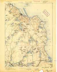
~ Plymouth MA topo map, 1:62500 scale, 15 X 15 Minute, Historical, 1889
Plymouth, Massachusetts, USGS topographic map dated 1889.
Includes geographic coordinates (latitude and longitude). This topographic map is suitable for hiking, camping, and exploring, or framing it as a wall map.
Printed on-demand using high resolution imagery, on heavy weight and acid free paper, or alternatively on a variety of synthetic materials.
Topos available on paper, Waterproof, Poly, or Tyvek. Usually shipping rolled, unless combined with other folded maps in one order.
- Product Number: USGS-5635809
- Free digital map download (high-resolution, GeoPDF): Plymouth, Massachusetts (file size: 8 MB)
- Map Size: please refer to the dimensions of the GeoPDF map above
- Weight (paper map): ca. 55 grams
- Map Type: POD USGS Topographic Map
- Map Series: HTMC
- Map Verison: Historical
- Cell ID: 61085
- Scan ID: 352953
- Survey Year: 1886
- Datum: Unstated
- Map Projection: Unstated
- Map published by United States Geological Survey
- Map Language: English
- Scanner Resolution: 600 dpi
- Map Cell Name: Plymouth
- Grid size: 15 X 15 Minute
- Date on map: 1889
- Map Scale: 1:62500
- Geographical region: Massachusetts, United States
Neighboring Maps:
All neighboring USGS topo maps are available for sale online at a variety of scales.
Spatial coverage:
Topo map Plymouth, Massachusetts, covers the geographical area associated the following places:
- Wareham Center - Ellisville - Pine Tree Village - Chiltonville - Cordage - Fort Standish - Kingston - Sagamore Highlands - Bourne Corners - Jefferson Shores - Priscilla Beach - Rocky Nook Point - East Wareham - Riverside - White Horse Beach - Oakdale - Onset Station - Eastland Heights - Pondville - Bournedale - Cedarville Landing - Manomet Beach - Halfway Pond - Fishermans Landing - Churchill Landing - Rocky Nook - South Pond - Rocky Nook Park - Patuxet (historical) - White Island Shores - Plimoth Commons Mobile Home Park - Sagamore - Cedar Bushes - Indian Heights - Plymouth Mobile Estates - Harlows Landing - Kingston Shores - Plymouth - Cranberry Village - South Carver - South Wareham - Beach Park - Jabez Corner - Nameloc Heights - Manomet - North Plymouth - Camp Mishannock - Pinehurst Mobile Home Village - Tihonet - Camp Norse - Bayside Beach - Vallersville - Manomet Bluffs - Cedarville - Wareham - Manomet Heights - Sagamore Beach
- Map Area ID: AREA4241.75-70.75-70.5
- Northwest corner Lat/Long code: USGSNW42-70.75
- Northeast corner Lat/Long code: USGSNE42-70.5
- Southwest corner Lat/Long code: USGSSW41.75-70.75
- Southeast corner Lat/Long code: USGSSE41.75-70.5
- Northern map edge Latitude: 42
- Southern map edge Latitude: 41.75
- Western map edge Longitude: -70.75
- Eastern map edge Longitude: -70.5


