
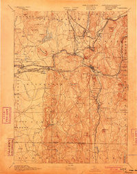
~ Palmer MA topo map, 1:62500 scale, 15 X 15 Minute, Historical, 1893, updated 1903
Palmer, Massachusetts, USGS topographic map dated 1893.
Includes geographic coordinates (latitude and longitude). This topographic map is suitable for hiking, camping, and exploring, or framing it as a wall map.
Printed on-demand using high resolution imagery, on heavy weight and acid free paper, or alternatively on a variety of synthetic materials.
Topos available on paper, Waterproof, Poly, or Tyvek. Usually shipping rolled, unless combined with other folded maps in one order.
- Product Number: USGS-5635765
- Free digital map download (high-resolution, GeoPDF): Palmer, Massachusetts (file size: 10 MB)
- Map Size: please refer to the dimensions of the GeoPDF map above
- Weight (paper map): ca. 55 grams
- Map Type: POD USGS Topographic Map
- Map Series: HTMC
- Map Verison: Historical
- Cell ID: 60721
- Scan ID: 352921
- Imprint Year: 1903
- Survey Year: 1887
- Datum: Unstated
- Map Projection: Unstated
- Map published by United States Geological Survey
- Map Language: English
- Scanner Resolution: 600 dpi
- Map Cell Name: Palmer
- Grid size: 15 X 15 Minute
- Date on map: 1893
- Map Scale: 1:62500
- Geographical region: Massachusetts, United States
Neighboring Maps:
All neighboring USGS topo maps are available for sale online at a variety of scales.
Spatial coverage:
Topo map Palmer, Massachusetts, covers the geographical area associated the following places:
- Palmer Center - Whipples - West Brimfield - Mileoak Corner - Butlerville - Three Rivers - Cold Spring - State Line - South Monson - Bondsville - Ludlow Center - Red Bridge - Fentonville - Indian Orchard - Palmer - Thorndike - Gibbs Crossing - Ludlow City - Colton Hollow - Ludlow - Four Corners - Blanchardville - Meadowbrook Green - Dingley Dell - Tenneyville - Baptist Village - North Monson - Monson - Palmer Green Estates - East Wilbraham - Wilbraham - Duckville - South Factory Village - Bardwell - Hampden - North Wilbraham - North Somers
- Map Area ID: AREA42.2542-72.5-72.25
- Northwest corner Lat/Long code: USGSNW42.25-72.5
- Northeast corner Lat/Long code: USGSNE42.25-72.25
- Southwest corner Lat/Long code: USGSSW42-72.5
- Southeast corner Lat/Long code: USGSSE42-72.25
- Northern map edge Latitude: 42.25
- Southern map edge Latitude: 42
- Western map edge Longitude: -72.5
- Eastern map edge Longitude: -72.25


