
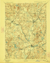
~ Groton MA topo map, 1:62500 scale, 15 X 15 Minute, Historical, 1893, updated 1923
Groton, Massachusetts, USGS topographic map dated 1893.
Includes geographic coordinates (latitude and longitude). This topographic map is suitable for hiking, camping, and exploring, or framing it as a wall map.
Printed on-demand using high resolution imagery, on heavy weight and acid free paper, or alternatively on a variety of synthetic materials.
Topos available on paper, Waterproof, Poly, or Tyvek. Usually shipping rolled, unless combined with other folded maps in one order.
- Product Number: USGS-5635549
- Free digital map download (high-resolution, GeoPDF): Groton, Massachusetts (file size: 9 MB)
- Map Size: please refer to the dimensions of the GeoPDF map above
- Weight (paper map): ca. 55 grams
- Map Type: POD USGS Topographic Map
- Map Series: HTMC
- Map Verison: Historical
- Cell ID: 54887
- Scan ID: 352760
- Imprint Year: 1923
- Survey Year: 1887
- Datum: Unstated
- Map Projection: Unstated
- Map published by United States Geological Survey
- Map Language: English
- Scanner Resolution: 600 dpi
- Map Cell Name: Groton
- Grid size: 15 X 15 Minute
- Date on map: 1893
- Map Scale: 1:62500
- Geographical region: Massachusetts, United States
Neighboring Maps:
All neighboring USGS topo maps are available for sale online at a variety of scales.
Spatial coverage:
Topo map Groton, Massachusetts, covers the geographical area associated the following places:
- South Brookline - Devenscrest - Devens - Shaker Village - Littleton - Fairlane Mobile Home Park - Green Acres Trailer Park - West Groton - North Pepperell - Brookline - Whalom - Burkinshaws Factory - Hollis - North Shirley - East Pepperell - Townsend - North Leominster - Groton - Hovey Corner - Old City - Harvard - Lunenburg Station - Four Corners - Shirley Center - Townsend Harbor - Meadow Wood Trailer Park - Pepperell - West Townsend - Pingryville - Hollis Depot - Willows - West Brookline - Lunenburg - Shaker Village - Suburban Village Trailer Park - West Hollis - Woodsville - Harvard Station - Goodrichville - Shirley - South Pepperell - Ayer - Paper Mill Village - Vose - Babbatasset Village - South Row
- Map Area ID: AREA42.7542.5-71.75-71.5
- Northwest corner Lat/Long code: USGSNW42.75-71.75
- Northeast corner Lat/Long code: USGSNE42.75-71.5
- Southwest corner Lat/Long code: USGSSW42.5-71.75
- Southeast corner Lat/Long code: USGSSE42.5-71.5
- Northern map edge Latitude: 42.75
- Southern map edge Latitude: 42.5
- Western map edge Longitude: -71.75
- Eastern map edge Longitude: -71.5


