
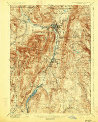
~ Greylock MA topo map, 1:62500 scale, 15 X 15 Minute, Historical, 1898, updated 1925
Greylock, Massachusetts, USGS topographic map dated 1898.
Includes geographic coordinates (latitude and longitude). This topographic map is suitable for hiking, camping, and exploring, or framing it as a wall map.
Printed on-demand using high resolution imagery, on heavy weight and acid free paper, or alternatively on a variety of synthetic materials.
Topos available on paper, Waterproof, Poly, or Tyvek. Usually shipping rolled, unless combined with other folded maps in one order.
- Product Number: USGS-5635531
- Free digital map download (high-resolution, GeoPDF): Greylock, Massachusetts (file size: 12 MB)
- Map Size: please refer to the dimensions of the GeoPDF map above
- Weight (paper map): ca. 55 grams
- Map Type: POD USGS Topographic Map
- Map Series: HTMC
- Map Verison: Historical
- Cell ID: 54870
- Scan ID: 352747
- Imprint Year: 1925
- Survey Year: 1885
- Datum: NAD
- Map Projection: Polyconic
- Map published by United States Geological Survey
- Map Language: English
- Scanner Resolution: 600 dpi
- Map Cell Name: Greylock
- Grid size: 15 X 15 Minute
- Date on map: 1898
- Map Scale: 1:62500
- Geographical region: Massachusetts, United States
Neighboring Maps:
All neighboring USGS topo maps are available for sale online at a variety of scales.
Spatial coverage:
Topo map Greylock, Massachusetts, covers the geographical area associated the following places:
- Williamstown - Savoy Center - The Spruces Mobile Home Park - Whitcomb Summit - Berkshire - Meadowvale - Houghtonville - Florida - South Williamstown - New Ashford - Cheshire - Hemlock Brook Estates - Bowens Corners - Briggsville - Little Egypt - East Renfrew - Greylock - Town Crest Village - Zylonite - Eastern Summit - West Summit - Steeles Corners - North Adams - Maple Grove - Camp Mohawk - Lanesborough - Arnoldville - Sweets Corner - White Oaks - Cheshire Harbor - Hemlock Brook (historical) - Adams - Brayton Hill - Savoy - Braytonville - Blackinton - Farnams - Renfrew - Willow Lane Adult Trailer Park - Windsor - Greylock Estates
- Map Area ID: AREA42.7542.5-73.25-73
- Northwest corner Lat/Long code: USGSNW42.75-73.25
- Northeast corner Lat/Long code: USGSNE42.75-73
- Southwest corner Lat/Long code: USGSSW42.5-73.25
- Southeast corner Lat/Long code: USGSSE42.5-73
- Northern map edge Latitude: 42.75
- Southern map edge Latitude: 42.5
- Western map edge Longitude: -73.25
- Eastern map edge Longitude: -73


