
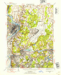
~ Springfield North MA topo map, 1:31680 scale, 7.5 X 7.5 Minute, Historical, 1946, updated 1954
Springfield North, Massachusetts, USGS topographic map dated 1946.
Includes geographic coordinates (latitude and longitude). This topographic map is suitable for hiking, camping, and exploring, or framing it as a wall map.
Printed on-demand using high resolution imagery, on heavy weight and acid free paper, or alternatively on a variety of synthetic materials.
Topos available on paper, Waterproof, Poly, or Tyvek. Usually shipping rolled, unless combined with other folded maps in one order.
- Product Number: USGS-5634861
- Free digital map download (high-resolution, GeoPDF): Springfield North, Massachusetts (file size: 10 MB)
- Map Size: please refer to the dimensions of the GeoPDF map above
- Weight (paper map): ca. 55 grams
- Map Type: POD USGS Topographic Map
- Map Series: HTMC
- Map Verison: Historical
- Cell ID: 42693
- Scan ID: 352212
- Imprint Year: 1954
- Woodland Tint: Yes
- Edit Year: 1946
- Survey Year: 1933
- Datum: NAD27
- Map Projection: Polyconic
- Map published by United States Geological Survey
- Map Language: English
- Scanner Resolution: 600 dpi
- Map Cell Name: Springfield North
- Grid size: 7.5 X 7.5 Minute
- Date on map: 1946
- Map Scale: 1:31680
- Geographical region: Massachusetts, United States
Neighboring Maps:
All neighboring USGS topo maps are available for sale online at a variety of scales.
Spatial coverage:
Topo map Springfield North, Massachusetts, covers the geographical area associated the following places:
- Fairview - Perry Manor - Cadys Corners - Scott Corners - Plainville (historical) - Aldenville - Springdale - South Hadley Falls - Willimansett - Highland Park - East Springfield - Chicopee - Holyoke - Elmwood - Duncan Knoll - Mathies Manor - Athol Junction - Oakdale - North Chicopee - Sandy Hill - Smith Highlands - Fiberloid - Great Swamp - Highlands - Freeman Knoll - Chicopee Falls
- Map Area ID: AREA42.2542.125-72.625-72.5
- Northwest corner Lat/Long code: USGSNW42.25-72.625
- Northeast corner Lat/Long code: USGSNE42.25-72.5
- Southwest corner Lat/Long code: USGSSW42.125-72.625
- Southeast corner Lat/Long code: USGSSE42.125-72.5
- Northern map edge Latitude: 42.25
- Southern map edge Latitude: 42.125
- Western map edge Longitude: -72.625
- Eastern map edge Longitude: -72.5


