
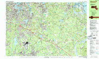
~ Weymouth MA topo map, 1:25000 scale, 7.5 X 15 Minute, Historical, 1984, updated 1984
Weymouth, Massachusetts, USGS topographic map dated 1984.
Includes geographic coordinates (latitude and longitude). This topographic map is suitable for hiking, camping, and exploring, or framing it as a wall map.
Printed on-demand using high resolution imagery, on heavy weight and acid free paper, or alternatively on a variety of synthetic materials.
Topos available on paper, Waterproof, Poly, or Tyvek. Usually shipping rolled, unless combined with other folded maps in one order.
- Product Number: USGS-5633857
- Free digital map download (high-resolution, GeoPDF): Weymouth, Massachusetts (file size: 37 MB)
- Map Size: please refer to the dimensions of the GeoPDF map above
- Weight (paper map): ca. 55 grams
- Map Type: POD USGS Topographic Map
- Map Series: HTMC
- Map Verison: Historical
- Cell ID: 75214
- Scan ID: 351419
- Imprint Year: 1984
- Woodland Tint: Yes
- Aerial Photo Year: 1978
- Edit Year: 1984
- Field Check Year: 1979
- Datum: NAD27
- Map Projection: Universal Transverse Mercator
- Map published by United States Geological Survey
- Map Language: English
- Scanner Resolution: 600 dpi
- Map Cell Name: Weymouth
- Grid size: 7.5 X 15 Minute
- Date on map: 1984
- Map Scale: 1:25000
- Geographical region: Massachusetts, United States
Neighboring Maps:
All neighboring USGS topo maps are available for sale online at a variety of scales.
Spatial coverage:
Topo map Weymouth, Massachusetts, covers the geographical area associated the following places:
- Liberty Plain - North Hanover - Brantwood Manor - Mungo Corner - Cohasset - Lincoln Heights - Braintree - Minot - East Braintree - Kings Landing - Quincy Neck - Mercer Square - Old Oaken Bucket Homestead - South Weymouth - Pine Grove - Cole Corner - Manns Corner - Clapps Corner - Finnville - Quincy Point - Lovell Corners - Weymouth Landing - Fort Hill - Idlewell - Weymouth Heights - Reeds Corner - North Abington - Norwell Homes - Scituate Center - Norwell - Hingham - Hatherly - Manson Corner - Hingham Center - South Braintree - Weymouth - Accord - Nantasket Junction - South Commons - North Scituate - Egypt - Black Rock - Rockland - Beechwood - Old Spain - Old Boat Point - West Hingham - North Weymouth - Tuttleville - Gannett Corners - East Weymouth - Jacobs Lake Shores - Sherman Corner - South Hingham - Assinippi - North Marshfield
- Map Area ID: AREA42.2542.125-71-70.75
- Northwest corner Lat/Long code: USGSNW42.25-71
- Northeast corner Lat/Long code: USGSNE42.25-70.75
- Southwest corner Lat/Long code: USGSSW42.125-71
- Southeast corner Lat/Long code: USGSSE42.125-70.75
- Northern map edge Latitude: 42.25
- Southern map edge Latitude: 42.125
- Western map edge Longitude: -71
- Eastern map edge Longitude: -70.75


