
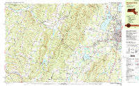
~ Pittsfield West MA topo map, 1:25000 scale, 7.5 X 15 Minute, Historical, 1988, updated 1988
Pittsfield West, Massachusetts, USGS topographic map dated 1988.
Includes geographic coordinates (latitude and longitude). This topographic map is suitable for hiking, camping, and exploring, or framing it as a wall map.
Printed on-demand using high resolution imagery, on heavy weight and acid free paper, or alternatively on a variety of synthetic materials.
Topos available on paper, Waterproof, Poly, or Tyvek. Usually shipping rolled, unless combined with other folded maps in one order.
- Product Number: USGS-5633727
- Free digital map download (high-resolution, GeoPDF): Pittsfield West, Massachusetts (file size: 31 MB)
- Map Size: please refer to the dimensions of the GeoPDF map above
- Weight (paper map): ca. 55 grams
- Map Type: POD USGS Topographic Map
- Map Series: HTMC
- Map Verison: Historical
- Cell ID: 75581
- Scan ID: 351225
- Imprint Year: 1988
- Woodland Tint: Yes
- Visual Version Number: 2
- Aerial Photo Year: 1981
- Edit Year: 1988
- Field Check Year: 1981
- Datum: NAD27
- Map Projection: Universal Transverse Mercator
- Map published by United States Geological Survey
- Map Language: English
- Scanner Resolution: 600 dpi
- Map Cell Name: Pittsfield West
- Grid size: 7.5 X 15 Minute
- Date on map: 1988
- Map Scale: 1:25000
- Geographical region: Massachusetts, United States
Neighboring Maps:
All neighboring USGS topo maps are available for sale online at a variety of scales.
Spatial coverage:
Topo map Pittsfield West, Massachusetts, covers the geographical area associated the following places:
- Canaan Center - Flatbrook - Canaan - Stearnsville - Lebanon Springs - Camp Witawentin - Barkerville - New Lebanon Center - Queechy - Camp Stevenson - Camp Marion White - Adams Crossing Mobile Home Park - Stevens Corner - Camp Russell - New Britain (historical) - West Lebanon - Hansons Mobile Home Park - West Pittsfield - Hancock Shaker Village - New Lebanon
- Map Area ID: AREA42.542.375-73.5-73.25
- Northwest corner Lat/Long code: USGSNW42.5-73.5
- Northeast corner Lat/Long code: USGSNE42.5-73.25
- Southwest corner Lat/Long code: USGSSW42.375-73.5
- Southeast corner Lat/Long code: USGSSE42.375-73.25
- Northern map edge Latitude: 42.5
- Southern map edge Latitude: 42.375
- Western map edge Longitude: -73.5
- Eastern map edge Longitude: -73.25


