
~ Norwood MA topo map, 1:25000 scale, 7.5 X 15 Minute, Historical, 1985, updated 1986
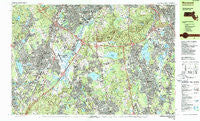
Norwood, Massachusetts, USGS topographic map dated 1985.
Includes geographic coordinates (latitude and longitude). This topographic map is suitable for hiking, camping, and exploring, or framing it as a wall map.
Printed on-demand using high resolution imagery, on heavy weight and acid free paper, or alternatively on a variety of synthetic materials.
Topos available on paper, Waterproof, Poly, or Tyvek. Usually shipping rolled, unless combined with other folded maps in one order.
- Product Number: USGS-5633709
- Free digital map download (high-resolution, GeoPDF): Norwood, Massachusetts (file size: 40 MB)
- Map Size: please refer to the dimensions of the GeoPDF map above
- Weight (paper map): ca. 55 grams
- Map Type: POD USGS Topographic Map
- Map Series: HTMC
- Map Verison: Historical
- Cell ID: 75137
- Scan ID: 351180
- Imprint Year: 1986
- Woodland Tint: Yes
- Aerial Photo Year: 1978
- Edit Year: 1985
- Field Check Year: 1979
- Datum: NAD27
- Map Projection: Universal Transverse Mercator
- Map published by United States Geological Survey
- Map Language: English
- Scanner Resolution: 600 dpi
- Map Cell Name: Norwood
- Grid size: 7.5 X 15 Minute
- Date on map: 1985
- Map Scale: 1:25000
- Geographical region: Massachusetts, United States
Neighboring Maps:
All neighboring USGS topo maps are available for sale online at a variety of scales.
Spatial coverage:
Topo map Norwood, Massachusetts, covers the geographical area associated the following places:
- Braintree Highlands - Stoughton - Belchers Corner (historical) - Walpole Heights - Walpole - Milton - North Stoughton - Canton Junction - Springdale - Readville Manor - Ashcroft - Randolph - Adamsville (historical) - Readville - Greenlodge - Westwood - South Quincy - Four Corners - Quincy Center - Holbrook - Canton - Norwood - West Stoughton - Winslows - Islington - Blue Hills - Brookville - Plimptonville - Avon - Summer Heights - Ponkapoag - Camp Sayre - Five Corners - North Commons - Ellis - Endicott - Oakdale - East Walpole - North Randolph - Dedham - West Corners (historical) - East Sharon
- Map Area ID: AREA42.2542.125-71.25-71
- Northwest corner Lat/Long code: USGSNW42.25-71.25
- Northeast corner Lat/Long code: USGSNE42.25-71
- Southwest corner Lat/Long code: USGSSW42.125-71.25
- Southeast corner Lat/Long code: USGSSE42.125-71
- Northern map edge Latitude: 42.25
- Southern map edge Latitude: 42.125
- Western map edge Longitude: -71.25
- Eastern map edge Longitude: -71


