
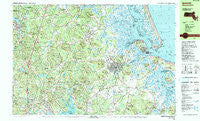
~ Ipswich MA topo map, 1:25000 scale, 7.5 X 15 Minute, Historical, 1985, updated 1986
Ipswich, Massachusetts, USGS topographic map dated 1985.
Includes geographic coordinates (latitude and longitude). This topographic map is suitable for hiking, camping, and exploring, or framing it as a wall map.
Printed on-demand using high resolution imagery, on heavy weight and acid free paper, or alternatively on a variety of synthetic materials.
Topos available on paper, Waterproof, Poly, or Tyvek. Usually shipping rolled, unless combined with other folded maps in one order.
- Product Number: USGS-5633663
- Free digital map download (high-resolution, GeoPDF): Ipswich, Massachusetts (file size: 35 MB)
- Map Size: please refer to the dimensions of the GeoPDF map above
- Weight (paper map): ca. 55 grams
- Map Type: POD USGS Topographic Map
- Map Series: HTMC
- Map Verison: Historical
- Cell ID: 75371
- Scan ID: 351040
- Imprint Year: 1986
- Woodland Tint: Yes
- Visual Version Number: 2
- Aerial Photo Year: 1978
- Edit Year: 1985
- Field Check Year: 1979
- Datum: NAD27
- Map Projection: Universal Transverse Mercator
- Map published by United States Geological Survey
- Map Language: English
- Scanner Resolution: 600 dpi
- Map Cell Name: Ipswich
- Grid size: 7.5 X 15 Minute
- Date on map: 1985
- Map Scale: 1:25000
- Geographical region: Massachusetts, United States
Neighboring Maps:
All neighboring USGS topo maps are available for sale online at a variety of scales.
Spatial coverage:
Topo map Ipswich, Massachusetts, covers the geographical area associated the following places:
- Ipswich - Rowley - South Essex - Hamilton - Boxford - Topsfield - Rooty Plain - Kings Forest - Kent Corner - Linebrook - East Boxford - Essex - Glen Mills - South Byfield - South Georgetown - Aqawam (historical) - Essex Falls - Pinefield - Leightons Corner - Georgetown - Nancys Corner - Marlboro - Kinsman Corner - Doles Corner - Little Neck - Camp Sea Haven
- Map Area ID: AREA42.7542.625-71-70.75
- Northwest corner Lat/Long code: USGSNW42.75-71
- Northeast corner Lat/Long code: USGSNE42.75-70.75
- Southwest corner Lat/Long code: USGSSW42.625-71
- Southeast corner Lat/Long code: USGSSE42.625-70.75
- Northern map edge Latitude: 42.75
- Southern map edge Latitude: 42.625
- Western map edge Longitude: -71
- Eastern map edge Longitude: -70.75


