
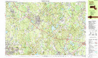
~ Franklin MA topo map, 1:25000 scale, 7.5 X 15 Minute, Historical, 1987, updated 1987
Franklin, Massachusetts, USGS topographic map dated 1987.
Includes geographic coordinates (latitude and longitude). This topographic map is suitable for hiking, camping, and exploring, or framing it as a wall map.
Printed on-demand using high resolution imagery, on heavy weight and acid free paper, or alternatively on a variety of synthetic materials.
Topos available on paper, Waterproof, Poly, or Tyvek. Usually shipping rolled, unless combined with other folded maps in one order.
- Product Number: USGS-5633623
- Free digital map download (high-resolution, GeoPDF): Franklin, Massachusetts (file size: 34 MB)
- Map Size: please refer to the dimensions of the GeoPDF map above
- Weight (paper map): ca. 55 grams
- Map Type: POD USGS Topographic Map
- Map Series: HTMC
- Map Verison: Historical
- Cell ID: 75836
- Scan ID: 350963
- Imprint Year: 1987
- Woodland Tint: Yes
- Visual Version Number: 1
- Aerial Photo Year: 1981
- Edit Year: 1987
- Field Check Year: 1982
- Datum: NAD27
- Map Projection: Universal Transverse Mercator
- Map published by United States Geological Survey
- Map Language: English
- Scanner Resolution: 600 dpi
- Map Cell Name: Franklin
- Grid size: 7.5 X 15 Minute
- Date on map: 1987
- Map Scale: 1:25000
- Geographical region: Massachusetts, United States
Neighboring Maps:
All neighboring USGS topo maps are available for sale online at a variety of scales.
Spatial coverage:
Topo map Franklin, Massachusetts, covers the geographical area associated the following places:
- Unionville - Pondville - Valley View - Wampum Corner - Plainville - Westview - Acorn Terrace - Wampum Rock - Midland - Franklin - Millerville - South Walpole - West Wrentham - Wethersfield - Cedar - Wadsworth - South Foxboro - Happy Hills - Wilkins Four Corners - Wrentham - Forest Park - Bellingham - Country View Estates - West Foxboro - North Foxboro - Grants Mills - Shepardville - Brushwood - Maple Ridge - Charles River Grove - Benjamins Landing - Robinsonville - South Bellingham - Crooks Corner - North Bellingham - Norfolk - City Mills - Rakeville - Scott Hill Acres - Sheldonville
- Map Area ID: AREA42.12542-71.5-71.25
- Northwest corner Lat/Long code: USGSNW42.125-71.5
- Northeast corner Lat/Long code: USGSNE42.125-71.25
- Southwest corner Lat/Long code: USGSSW42-71.5
- Southeast corner Lat/Long code: USGSSE42-71.25
- Northern map edge Latitude: 42.125
- Southern map edge Latitude: 42
- Western map edge Longitude: -71.5
- Eastern map edge Longitude: -71.25


