
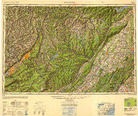
~ Scranton PA topo map, 1:250000 scale, 1 X 2 Degree, Historical, 1950, updated 1952
Scranton, Pennsylvania, USGS topographic map dated 1950.
Includes geographic coordinates (latitude and longitude). This topographic map is suitable for hiking, camping, and exploring, or framing it as a wall map.
Printed on-demand using high resolution imagery, on heavy weight and acid free paper, or alternatively on a variety of synthetic materials.
Topos available on paper, Waterproof, Poly, or Tyvek. Usually shipping rolled, unless combined with other folded maps in one order.
- Product Number: USGS-5631301
- Free digital map download (high-resolution, GeoPDF): Scranton, Pennsylvania (file size: 18 MB)
- Map Size: please refer to the dimensions of the GeoPDF map above
- Weight (paper map): ca. 55 grams
- Map Type: POD USGS Topographic Map
- Map Series: HTMC
- Map Verison: Historical
- Cell ID: 69021
- Scan ID: 707601
- Imprint Year: 1952
- Woodland Tint: Yes
- Aerial Photo Year: 1944
- Datum: NAD27
- Map Projection: Transverse Mercator
- Shaded Relief map: Yes
- Map published by United States Army Corps of Engineers
- Map published by United States Army
- Map Language: English
- Scanner Resolution: 508 dpi
- Map Cell Name: Scranton
- Grid size: 1 X 2 Degree
- Date on map: 1950
- Map Scale: 1:250000
- Geographical region: Pennsylvania, United States
Neighboring Maps:
All neighboring USGS topo maps are available for sale online at a variety of scales.
Spatial coverage:
Topo map Scranton, Pennsylvania, covers the geographical area associated the following places:
- Lackawack - Big Island - Bevans - Loomis Mobile Home Park - Angels - Canterbury Estates - Conklin Hill - Frutchey - Drums - Allard Corners - Moosehead - Erskine Lakes - Stewart Terrace - Stanton Corner - Walton Park - Potterville - Tooley Corners - Orange Lake - Dingmans Ferry - Susquehanna - Doodletown (historical) - Church Street Mobile Home Park - Hewitt - Greentown - Sand Hills - Smallwood - Stillwater Lake Estates - Westminster - Mombaccus - Milanville - Edella - High View - Wawarsing - Snow Hill Falls - Lake Harmony - Valley View Mobile Home Park - Ewen - Hurleyville - East Spruce - Providence - Clearwater - Harmony Hills - Rowland - Lemon - Port Bowkley - Monsey - Wykertown - Awosting - Browns - Wilderness Acres - Winton - Thiells - Buttonwood - Pink - Rosengrant - Unionville - Fairview Heights - Spencer Corner - Nicholson - Mount Pocono - Ararat - Forestburg - Parsons - Kingston - McAfee - Carverton - Lake Como - Melrose - Swiftwater - Anderson - Riggsville - Macopin - Upper Greenwood Lake - Pine Bush - Clintondale - Bruceville - Chase - Forest Glen - Bull Mine - Four Corners - Baoba - Starks - Witinski Villa - Kyserike - Montebello - Tunkhannock - Maybrook - Maplewood Heights - Suffern Park - Trucksville - Napanoch - Mountain Lodge Park - Preserve - Pine Ridge - Avoy - Smiley - Nuangola Station - Lake Carey - Pocono Mountain Lake Estates - Finchville
- Map Area ID: AREA4241-76-74
- Northwest corner Lat/Long code: USGSNW42-76
- Northeast corner Lat/Long code: USGSNE42-74
- Southwest corner Lat/Long code: USGSSW41-76
- Southeast corner Lat/Long code: USGSSE41-74
- Northern map edge Latitude: 42
- Southern map edge Latitude: 41
- Western map edge Longitude: -76
- Eastern map edge Longitude: -74


