
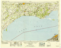
~ Erie PA topo map, 1:250000 scale, 1 X 2 Degree, Historical, 1950, updated 1953
Erie, Pennsylvania, USGS topographic map dated 1950.
Includes geographic coordinates (latitude and longitude). This topographic map is suitable for hiking, camping, and exploring, or framing it as a wall map.
Printed on-demand using high resolution imagery, on heavy weight and acid free paper, or alternatively on a variety of synthetic materials.
Topos available on paper, Waterproof, Poly, or Tyvek. Usually shipping rolled, unless combined with other folded maps in one order.
- Product Number: USGS-5631299
- Free digital map download (high-resolution, GeoPDF): Erie, Pennsylvania (file size: 21 MB)
- Map Size: please refer to the dimensions of the GeoPDF map above
- Weight (paper map): ca. 55 grams
- Map Type: POD USGS Topographic Map
- Map Series: HTMC
- Map Verison: Historical
- Cell ID: 68770
- Scan ID: 172503
- Imprint Year: 1953
- Woodland Tint: Yes
- Aerial Photo Year: 1939
- Datum: NAD27
- Map Projection: Transverse Mercator
- Map published by United States Army Corps of Engineers
- Map published by United States Army
- Map Language: English
- Scanner Resolution: 600 dpi
- Map Cell Name: Erie
- Grid size: 1 X 2 Degree
- Date on map: 1950
- Map Scale: 1:250000
- Geographical region: Pennsylvania, United States
Neighboring Maps:
All neighboring USGS topo maps are available for sale online at a variety of scales.
Spatial coverage:
Topo map Erie, Pennsylvania, covers the geographical area associated the following places:
- Sterrettania - Kanty - Dock Junction - Five Points - Belleview Heights - Weis Library - Swanville - Girard Junction - Langdon - Asbury - Vernondale - Chestnut Hill - Fairfield - Girard - Wesleyville - Erie Heights - Glenruadh - Westminster - Kearsarge - West Millcreek - Weber Hills - Belle Valley - Avonia - Glenwood - Erie - Fairplain - Lake City - Godard - Lakewood - Manchester Beach - Jackson - Fairview - Pleasant Hill - Wallace Junction - Highland Park - Eaglehurst - Lawrence Park - Charter Oaks - Glenmar Gardens
- Map Area ID: AREA4342-82-80
- Northwest corner Lat/Long code: USGSNW43-82
- Northeast corner Lat/Long code: USGSNE43-80
- Southwest corner Lat/Long code: USGSSW42-82
- Southeast corner Lat/Long code: USGSSE42-80
- Northern map edge Latitude: 43
- Southern map edge Latitude: 42
- Western map edge Longitude: -82
- Eastern map edge Longitude: -80


