
~ Mcalester OK topo map, 1:250000 scale, 1 X 2 Degree, Historical, 1950, updated 1950
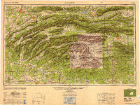
Mcalester, Oklahoma, USGS topographic map dated 1950.
Includes geographic coordinates (latitude and longitude). This topographic map is suitable for hiking, camping, and exploring, or framing it as a wall map.
Printed on-demand using high resolution imagery, on heavy weight and acid free paper, or alternatively on a variety of synthetic materials.
Topos available on paper, Waterproof, Poly, or Tyvek. Usually shipping rolled, unless combined with other folded maps in one order.
- Product Number: USGS-5631293
- Free digital map download (high-resolution, GeoPDF): Mcalester, Oklahoma (file size: 17 MB)
- Map Size: please refer to the dimensions of the GeoPDF map above
- Weight (paper map): ca. 55 grams
- Map Type: POD USGS Topographic Map
- Map Series: HTMC
- Map Verison: Historical
- Cell ID: 68897
- Scan ID: 707466
- Imprint Year: 1950
- Woodland Tint: Yes
- Aerial Photo Year: 1946
- Datum: NAD27
- Map Projection: Transverse Mercator
- Shaded Relief map: Yes
- Map published by United States Army Corps of Engineers
- Map published by United States Army
- Map Language: English
- Scanner Resolution: 508 dpi
- Map Cell Name: McAlester
- Grid size: 1 X 2 Degree
- Date on map: 1950
- Map Scale: 1:250000
- Geographical region: Oklahoma, United States
Neighboring Maps:
All neighboring USGS topo maps are available for sale online at a variety of scales.
Spatial coverage:
Topo map Mcalester, Oklahoma, covers the geographical area associated the following places:
- Mena - Beachton - Daisy - Fanshawe - Lone Elm - Nelson - Ti - Kosoma - Chant (historical) - Morgan Springs - Snow - Red Hill (historical) - Potter Junction - Bethany - Chambers - Valliant - Clayton Spur (historical) - Dow - Y City - Pine Knot Crossing - Tuskahoma - Virgil - Burg - Battiest - Martha (historical) - Old Cove - Crystal - Haywood - Albion - Hatfield - Patterson - Sardis - Farris - Counts - Pleasant Hill - Petros - Pleasant Hill - Wright City - Glendale - Shady - Honobia - Green Ridge - Hodgen - Centerville - Corinth - Valley Ridge (historical) - Bache - McAlester - Sunshine (historical) - Boswell - Hochatown - Patterson - Monroe - Hatton - Tintop - Stephens Gap - Bethel (historical) - Old Union (historical) - Evening Shade - Arpelar - Brewer - Reichert - Yocana - Wesley - Howe - Victor - Pine Grove - Pickens - Antioch (historical) - Ultima Thule - High Hill - North McAlester - Sensation (historical) - Adel - Weathers - Tiner - Summerfield - Buck Creek Landing - Bond - Lutie - Rufe - Umpire - Hartley - Payton Crossing - Fewell - Independence - Wister - Belzoni - Dunbar - New Moon (historical) - Caston - West Fort Towson - Hodgens Station - Sunkist - Boehler - The Pines - Golden - Bog Springs - Moyers - Felker
- Map Area ID: AREA3534-96-94
- Northwest corner Lat/Long code: USGSNW35-96
- Northeast corner Lat/Long code: USGSNE35-94
- Southwest corner Lat/Long code: USGSSW34-96
- Southeast corner Lat/Long code: USGSSE34-94
- Northern map edge Latitude: 35
- Southern map edge Latitude: 34
- Western map edge Longitude: -96
- Eastern map edge Longitude: -94


