
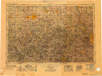
~ Canton OH topo map, 1:250000 scale, 1 X 2 Degree, Historical, 1951, updated 1951
Canton, Ohio, USGS topographic map dated 1951.
Includes geographic coordinates (latitude and longitude). This topographic map is suitable for hiking, camping, and exploring, or framing it as a wall map.
Printed on-demand using high resolution imagery, on heavy weight and acid free paper, or alternatively on a variety of synthetic materials.
Topos available on paper, Waterproof, Poly, or Tyvek. Usually shipping rolled, unless combined with other folded maps in one order.
- Product Number: USGS-5631291
- Free digital map download (high-resolution, GeoPDF): Canton, Ohio (file size: 19 MB)
- Map Size: please refer to the dimensions of the GeoPDF map above
- Weight (paper map): ca. 55 grams
- Map Type: POD USGS Topographic Map
- Map Series: HTMC
- Map Verison: Historical
- Cell ID: 68700
- Scan ID: 707259
- Imprint Year: 1951
- Woodland Tint: Yes
- Aerial Photo Year: 1943
- Datum: NAD27
- Map Projection: Transverse Mercator
- Map published by United States Army Corps of Engineers
- Map published by United States Army
- Map Language: English
- Scanner Resolution: 508 dpi
- Map Cell Name: Canton
- Grid size: 1 X 2 Degree
- Date on map: 1951
- Map Scale: 1:250000
- Geographical region: Ohio, United States
Neighboring Maps:
All neighboring USGS topo maps are available for sale online at a variety of scales.
Spatial coverage:
Topo map Canton, Ohio, covers the geographical area associated the following places:
- Maynard - East Finley - Baden - Holidays Cove - Hillcrest - Walnut Hills - Murdocksville - Summit (historical) - Wallace Heights - Greggsville - Deersville - Waterside - Brookside - Hillview Mobile Court - Spruce Tree Village - Mayflower Village - Hearthstone Estates - Finleyville - Mechanicstown - East Shore Cottage Area - New Alexander - Prosperity - Goehring - Moon Crest - Laboratory - Cassell - Thomas - Gambles - Fairfield - Woodrow - Chili - Blairmont - Oakgrove - Negley - Five Forks - Beaver Street Trailer Court - Haysville - Trump - Potomac - Braithewaite (historical) - Wheat Hill Estates - Fayetteville - Kenwood - New Manchester - Beechwood - Old Town - Carman - Brevard - Mount Union (historical) - Glasgow - Isleta - Ginger Hill - Limaville - Library Junction - Fairhaven - Orange - East Palestine - Sparta - Bishop Meadows - Moninger - Weilersville - Crestmont Village - Bethany - Fernway - Tappan - Wheeling Valley (historical) - Bellevue - Clear View Heights - Five Points - Turkeyfoot - Meadow Village - Rich Hill - Shady Glen - Sewellsville - Greenfield Farms - Van Voorhis Hill - Northgate - Greensburg - Morgan Run - Tower Terrace - Cloverdale - Shady Knoll Mobile Park - Stoops Ferry - Georgetown - Adair's Trailer Park - Grant City - Venetia - Edgefield - Coverdale - Whitestown - Town And Country Park Estates - Tremleys (historical) - Farmington - Allegheny Center - Patmos - Weirton - North Lima - Duncanwood - Leetsdale - Midway
- Map Area ID: AREA4140-82-80
- Northwest corner Lat/Long code: USGSNW41-82
- Northeast corner Lat/Long code: USGSNE41-80
- Southwest corner Lat/Long code: USGSSW40-82
- Southeast corner Lat/Long code: USGSSE40-80
- Northern map edge Latitude: 41
- Southern map edge Latitude: 40
- Western map edge Longitude: -82
- Eastern map edge Longitude: -80


