
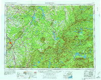
~ Sherbrooke ME topo map, 1:250000 scale, 1 X 2 Degree, Historical, 1976, updated 1976
Sherbrooke, Maine, USGS topographic map dated 1976.
Includes geographic coordinates (latitude and longitude). This topographic map is suitable for hiking, camping, and exploring, or framing it as a wall map.
Printed on-demand using high resolution imagery, on heavy weight and acid free paper, or alternatively on a variety of synthetic materials.
Topos available on paper, Waterproof, Poly, or Tyvek. Usually shipping rolled, unless combined with other folded maps in one order.
- Product Number: USGS-5631219
- Free digital map download (high-resolution, GeoPDF): Sherbrooke, Maine (file size: 17 MB)
- Map Size: please refer to the dimensions of the GeoPDF map above
- Weight (paper map): ca. 55 grams
- Map Type: POD USGS Topographic Map
- Map Series: HTMC
- Map Verison: Historical
- Cell ID: 75022
- Scan ID: 807150
- Imprint Year: 1976
- Woodland Tint: Yes
- Field Check Year: 1961
- Datum: Unstated
- Map Projection: Transverse Mercator
- Map published by United States Army Corps of Engineers
- Map published by United States Army
- Map Language: English
- Scanner Resolution: 508 dpi
- Map Cell Name: Sherbrooke
- Grid size: 1 X 2 Degree
- Date on map: 1976
- Map Scale: 1:250000
- Geographical region: Maine, United States
Neighboring Maps:
All neighboring USGS topo maps are available for sale online at a variety of scales.
Spatial coverage:
Topo map Sherbrooke, Maine, covers the geographical area associated the following places:
- Lake Parlin (historical) - Round Mountain - Lowelltown - Skinner - Attean Landing - The Landing - Jackman Mill (historical) - Moose River - Beecher Falls - Blair - Dyerville - Mackamp - Norton - Dennistown - Eustis - Keough - Idlewilde - Bigelow - Spring Lake Landing - Jackman - Carrabassett - Dead River (historical) - Hayden Landing - Pittsburg - Coburn Gore - Kennebago - Kamankeag (historical) - The Glen - Stratton - Langtown Mill - Stewartstown - Attean (historical) - Holeb - West Forks - Kennebago Settlement - Long Pond - Wallace Pond - Loon Lake - Davis Town - Moosehorn (historical) - Happy Corner - Spring Lake - Grants Camps - Three Streams
- Map Area ID: AREA4645-72-70
- Northwest corner Lat/Long code: USGSNW46-72
- Northeast corner Lat/Long code: USGSNE46-70
- Southwest corner Lat/Long code: USGSSW45-72
- Southeast corner Lat/Long code: USGSSE45-70
- Northern map edge Latitude: 46
- Southern map edge Latitude: 45
- Western map edge Longitude: -72
- Eastern map edge Longitude: -70


