
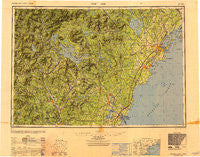
~ Portland ME topo map, 1:250000 scale, 1 X 2 Degree, Historical, 1949, updated 1950
Portland, Maine, USGS topographic map dated 1949.
Includes geographic coordinates (latitude and longitude). This topographic map is suitable for hiking, camping, and exploring, or framing it as a wall map.
Printed on-demand using high resolution imagery, on heavy weight and acid free paper, or alternatively on a variety of synthetic materials.
Topos available on paper, Waterproof, Poly, or Tyvek. Usually shipping rolled, unless combined with other folded maps in one order.
- Product Number: USGS-5631207
- Free digital map download (high-resolution, GeoPDF): Portland, Maine (file size: 19 MB)
- Map Size: please refer to the dimensions of the GeoPDF map above
- Weight (paper map): ca. 55 grams
- Map Type: POD USGS Topographic Map
- Map Series: HTMC
- Map Verison: Historical
- Cell ID: 68970
- Scan ID: 707528
- Imprint Year: 1950
- Woodland Tint: Yes
- Aerial Photo Year: 1942
- Datum: NAD27
- Map Projection: Transverse Mercator
- Shaded Relief map: Yes
- Map published by United States Army Corps of Engineers
- Map published by United States Army
- Map Language: English
- Scanner Resolution: 508 dpi
- Map Cell Name: Portland
- Grid size: 1 X 2 Degree
- Date on map: 1949
- Map Scale: 1:250000
- Geographical region: Maine, United States
Neighboring Maps:
All neighboring USGS topo maps are available for sale online at a variety of scales.
Spatial coverage:
Topo map Portland, Maine, covers the geographical area associated the following places:
- Dockham Shore - Northwood Narrows - York Corner - Boyce - Plummer Mill - Swetts Mills - Jones Mills - Ligonia - Madbury - Shingle Mill Corner - Deering - Foundry - Loon Cove - Boyd Corner - Waites Landing - Rollinsford - Rumney Depot - Wilmot Flat - North Wilmot - South Weare - South Wolfeboro - West Denmark - West Ossipee - Leighton Corners - Webster - Emery Mills - South Hiram - Chadbournes Mills - Eaton Center - Wildes Corner - Sebago Lake - York Village - Chicopee - Emerys Corner - State Landing - East Wolfeboro - Edes Falls - Kimbles Corner - Salisbury Heights - Bradford - South Alexandria - Spring Haven - Shaker Village - Ossipee Valley - Peaks Island - South Bridgton - East Springfield - Varney Crossing - Cushing Island - Chicks Corner - Alton - Horse Corner - Quincy - North Deering - Roby - Falmouth - Greenland - Blackwater - Alton Bay - Pittsfield - West Scarborough - East Candia - Penacook - Loudon Center - Clay Hill - Allenstown Elementary School - Moultonborough Falls - Rye North Beach - Cumberland Center Station - Limington - Roberts Corner - Meaderboro Corner - Highpine - Tyler - Place - Newington Station - Foggs Corner - Lower Village (historical) - Merrill Corner - Shaw Mills - Center Tuftonboro - Bedell Crossing - Scribners Corner - New Portsmouth - Gilmanton Ironworks - Upper Landing - Deerfield Parade - Little Diamond Island Landing - Milliken Mills - Emerys Bridge - Center Conway - Windham Hill - East Andover - Tylers Corner - West Barrington - Fort Gorges - Camp Ellis - Waterboro - Paugus Mill - Allens Mills
- Map Area ID: AREA4443-72-70
- Northwest corner Lat/Long code: USGSNW44-72
- Northeast corner Lat/Long code: USGSNE44-70
- Southwest corner Lat/Long code: USGSSW43-72
- Southeast corner Lat/Long code: USGSSE43-70
- Northern map edge Latitude: 44
- Southern map edge Latitude: 43
- Western map edge Longitude: -72
- Eastern map edge Longitude: -70


