
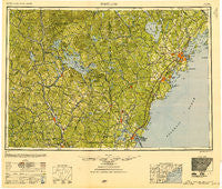
~ Portland ME topo map, 1:250000 scale, 1 X 2 Degree, Historical, 1949, updated 1951
Portland, Maine, USGS topographic map dated 1949.
Includes geographic coordinates (latitude and longitude). This topographic map is suitable for hiking, camping, and exploring, or framing it as a wall map.
Printed on-demand using high resolution imagery, on heavy weight and acid free paper, or alternatively on a variety of synthetic materials.
Topos available on paper, Waterproof, Poly, or Tyvek. Usually shipping rolled, unless combined with other folded maps in one order.
- Product Number: USGS-5631201
- Free digital map download (high-resolution, GeoPDF): Portland, Maine (file size: 23 MB)
- Map Size: please refer to the dimensions of the GeoPDF map above
- Weight (paper map): ca. 55 grams
- Map Type: POD USGS Topographic Map
- Map Series: HTMC
- Map Verison: Historical
- Cell ID: 68970
- Scan ID: 330414
- Imprint Year: 1951
- Woodland Tint: Yes
- Aerial Photo Year: 1942
- Datum: NAD27
- Map Projection: Transverse Mercator
- Map published by United States Army Corps of Engineers
- Map published by United States Army
- Map Language: English
- Scanner Resolution: 600 dpi
- Map Cell Name: Portland
- Grid size: 1 X 2 Degree
- Date on map: 1949
- Map Scale: 1:250000
- Geographical region: Maine, United States
Neighboring Maps:
All neighboring USGS topo maps are available for sale online at a variety of scales.
Spatial coverage:
Topo map Portland, Maine, covers the geographical area associated the following places:
- Greenland - Sandwich - McKinley Estates - Grasmere - East Holderness - Granite - Five Points - Cape Neddick - Tripoli Mill - Center Effingham - Hopkinton - Macs Corner - Bow Center - Ellsworth - North Pownal - Cozy Corners - Dover - Pollys Crossing - Hobbs Crossing - Woodfords - Meredith Center - Cutts Island - Gilmanton Ironworks - Clark Hill - Western Landing - North Deering - Tavern Village - Sawyers - Denmark - Grape Corner - Harmon Beach - Lisbon Falls - Tilton - Pine Hill - Great Works - Melvin Village - North Lebanon - Merriwood Camp - Gardners Grove - Glantz Corner - Tattle Corner - Weare - Kennebunk - York Cliffs - Strafford Corner - Dry Mills - East Brownfield - Long Island - Chicopee - Guinea Corner - Bow Lake Village - East Hebron - Shapleigh - Shingle Mill Corner - Blaisdell Corners - Suncook - South Lebanon - Allens Mills - Cape Elizabeth - Brickyard Landing (historical) - Onway Lake - Emerys Corner - York Harbor - Cilleyville - Pearls Corner - North Epping - Ossipee Mills - Pequawket - East Candia - Candia Four Corners - North Weare - Wallis Sands - Growstown - Cornish - South Effingham - Merrill Corners - Hornetown - Oak Hill - Peaks Island - Foristall Corners - East Bear Island - Libbytown - Middleton Corners - Newhall - East Tilton - North Berwick - Scituate - Little Falls - Cape Cottage - North Wolfeboro - New Castle - Seavey Island - Boothbay Park - South Durham - Melrose Beach - Raymond - Fort Lyon - South Tamworth - Lower Landing - Pond Cove
- Map Area ID: AREA4443-72-70
- Northwest corner Lat/Long code: USGSNW44-72
- Northeast corner Lat/Long code: USGSNE44-70
- Southwest corner Lat/Long code: USGSSW43-72
- Southeast corner Lat/Long code: USGSSE43-70
- Northern map edge Latitude: 44
- Southern map edge Latitude: 43
- Western map edge Longitude: -72
- Eastern map edge Longitude: -70


