
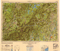
~ Lewiston ME topo map, 1:250000 scale, 1 X 2 Degree, Historical, 1950, updated 1950
Lewiston, Maine, USGS topographic map dated 1950.
Includes geographic coordinates (latitude and longitude). This topographic map is suitable for hiking, camping, and exploring, or framing it as a wall map.
Printed on-demand using high resolution imagery, on heavy weight and acid free paper, or alternatively on a variety of synthetic materials.
Topos available on paper, Waterproof, Poly, or Tyvek. Usually shipping rolled, unless combined with other folded maps in one order.
- Product Number: USGS-5631197
- Free digital map download (high-resolution, GeoPDF): Lewiston, Maine (file size: 18 MB)
- Map Size: please refer to the dimensions of the GeoPDF map above
- Weight (paper map): ca. 55 grams
- Map Type: POD USGS Topographic Map
- Map Series: HTMC
- Map Verison: Historical
- Cell ID: 75018
- Scan ID: 707443
- Imprint Year: 1950
- Woodland Tint: Yes
- Aerial Photo Year: 1944
- Datum: NAD27
- Map Projection: Transverse Mercator
- Shaded Relief map: Yes
- Map published by United States Army Corps of Engineers
- Map published by United States Army
- Map Language: English
- Scanner Resolution: 508 dpi
- Map Cell Name: Lewiston
- Grid size: 1 X 2 Degree
- Date on map: 1950
- Map Scale: 1:250000
- Geographical region: Maine, United States
Neighboring Maps:
All neighboring USGS topo maps are available for sale online at a variety of scales.
Spatial coverage:
Topo map Lewiston, Maine, covers the geographical area associated the following places:
- Glen - Boutin Corner - Maplewood - Youngs Corner - Abbotts Mill - Damon Crossing - Jackson Falls - Benton - Franconia - Avon - Livermore - Dryden - Dixville Notch - Stillwater - Wilton - East Poland - West Bowdoin - Hanover - Grange - Canton Point - Leeds Junction - Howes Corner - North Lovell - Deerfield - North Concord - Norway Center - North Norway - Rumford Junction - North Turner - Scates Corner - Soule Mill - Milan - East Wales - North Wayne - Mexico - South Rumford - East Milton - Harmons Corner - Avon Corner - West Milan - Bullthroat - Hildreths Mill - East Wilton - Gateway Trailer Park - West Minot - Browns Mill - East Peru - Fabyan - Madrid Junction - Weld Corner - Leeds - Smith Crossing - Poland Spring - Columbia - Twin Mountain - Turner - Apthorp - North Buckfield - Auburn Plains - Stuarts Corner - East Waterford - Fryeburg Center - Norway Lake - Poland - North Kirby - East Lyndon - Mayville - East Buckfield - Sanderson Corners - Gilead - East Saint Johnsbury - New Vineyard - Bethel - Toneys Mobile Park - Moccasin Mill - Marshfield Station - Blake Corner - Sodom - Quebec Junction - Arlins - Jackson - Redington - Bolsters Mills - Knowltons Corner - Liberty Corner - Masons - West Bath - North Woodstock - Oquossoc - Plummer Landing - Welchville - Barrett - East Haverhill - Promised Land - East Auburn - MacQuillis Corner - Phillips - Columbia - Rumford Point - Twelve Corners
- Map Area ID: AREA4544-72-70
- Northwest corner Lat/Long code: USGSNW45-72
- Northeast corner Lat/Long code: USGSNE45-70
- Southwest corner Lat/Long code: USGSSW44-72
- Southeast corner Lat/Long code: USGSSE44-70
- Northern map edge Latitude: 45
- Southern map edge Latitude: 44
- Western map edge Longitude: -72
- Eastern map edge Longitude: -70


