
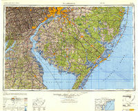
~ Wilmington DE topo map, 1:250000 scale, 1 X 2 Degree, Historical, 1946, updated 1948
Wilmington, Delaware, USGS topographic map dated 1946.
Includes geographic coordinates (latitude and longitude). This topographic map is suitable for hiking, camping, and exploring, or framing it as a wall map.
Printed on-demand using high resolution imagery, on heavy weight and acid free paper, or alternatively on a variety of synthetic materials.
Topos available on paper, Waterproof, Poly, or Tyvek. Usually shipping rolled, unless combined with other folded maps in one order.
- Product Number: USGS-5631149
- Free digital map download (high-resolution, GeoPDF): Wilmington, Delaware (file size: 17 MB)
- Map Size: please refer to the dimensions of the GeoPDF map above
- Weight (paper map): ca. 55 grams
- Map Type: POD USGS Topographic Map
- Map Series: HTMC
- Map Verison: Historical
- Cell ID: 69102
- Scan ID: 707694
- Imprint Year: 1948
- Woodland Tint: Yes
- Aerial Photo Year: 1943
- Datum: NAD27
- Map Projection: Transverse Mercator
- Shaded Relief map: Yes
- Map published by United States Army Corps of Engineers
- Map published by United States Army
- Map Language: English
- Scanner Resolution: 508 dpi
- Map Cell Name: Wilmington
- Grid size: 1 X 2 Degree
- Date on map: 1946
- Map Scale: 1:250000
- Geographical region: Delaware, United States
Neighboring Maps:
All neighboring USGS topo maps are available for sale online at a variety of scales.
Spatial coverage:
Topo map Wilmington, Delaware, covers the geographical area associated the following places:
- High Bank Landing - Capitol Green - Woodbine - Chelsea Estates - Westmont - Fairview Estates - Dilworthtown - Ridley Park - Dragston - Glenside - Ben Lee Estates - Parkside - Country Lake Estates - Ainsley Woods - Oak Lane Manor - Forest Park - Sharps Corner - Ingleside - Wind Song Farms - Carlisle Village - The Meadows at Elk Creek - Middleboro Manor - Dans - Paulsboro - Jericho - Good Intent - Wrange Hill Estates - Hollingsworth Circle - Knowlton - Newlinville - Pilgrim Gardens - Candlewicke - Steelville - Bishops Corner - Mount Holly - Wedgewood - Delpark Manor - Daniels Tract - Quinton - Centennial Village - Hillendale - Rose Valley Estates - Stage Road Development - Fairview - Cranberry Hill - Garwood Estates - Woodside Hills - Beacon Hill - Folsom - New Brooklyn - Friendship - Presidential Lake Estates - Cambridge - Wood Wards Addition - Stonehaven - Robanna - Academy Hills - Westcotville - Fisher Corners - Edgebrooke - Kimbles Beach - Goshen Commons - Wilwon Woods - Sycamore Farms - Gams Crest - Turnersville - West Meadow - Armstrong - Lancashire - Mariners Cove - Hickory Hill - Deer Lake Park - Brackenville - West Riding - The Cedars - Silver Beach - Devonshire - Huntley Circle - Waretown - Victory Lakes - Ocean Beach - Deerbrook I - Windy Bush - Mower - Elam - Felton Manor - Wawaset - Burleigh - Buck Run - Stone Harbor Manor - Caswallen - Hayden Park - Maurice River - Christiana Green - Hazelwood - Winterbury - Commerce Square - Friesburg - Blake - Longview Farms
- Map Area ID: AREA4039-76-74
- Northwest corner Lat/Long code: USGSNW40-76
- Northeast corner Lat/Long code: USGSNE40-74
- Southwest corner Lat/Long code: USGSSW39-76
- Southeast corner Lat/Long code: USGSSE39-74
- Northern map edge Latitude: 40
- Southern map edge Latitude: 39
- Western map edge Longitude: -76
- Eastern map edge Longitude: -74


