
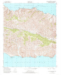
~ Santa Cruz Island B CA topo map, 1:24000 scale, 7.5 X 7.5 Minute, Historical, 1943, updated 1984
Santa Cruz Island B, California, USGS topographic map dated 1943.
Includes geographic coordinates (latitude and longitude). This topographic map is suitable for hiking, camping, and exploring, or framing it as a wall map.
Printed on-demand using high resolution imagery, on heavy weight and acid free paper, or alternatively on a variety of synthetic materials.
Topos available on paper, Waterproof, Poly, or Tyvek. Usually shipping rolled, unless combined with other folded maps in one order.
- Product Number: USGS-5631065
- Free digital map download (high-resolution, GeoPDF): Santa Cruz Island B, California (file size: 17 MB)
- Map Size: please refer to the dimensions of the GeoPDF map above
- Weight (paper map): ca. 55 grams
- Map Type: POD USGS Topographic Map
- Map Series: HTMC
- Map Verison: Historical
- Cell ID: 39891
- Scan ID: 300257
- Imprint Year: 1984
- Woodland Tint: Yes
- Visual Version Number: 1
- Aerial Photo Year: 1943
- Field Check Year: 1943
- Datum: NAD27
- Map Projection: Polyconic
- Map published by United States Geological Survey
- Map published by United States Army Corps of Engineers
- Map published by United States Army
- Map Language: English
- Scanner Resolution: 600 dpi
- Map Cell Name: Santa Cruz Island B
- Grid size: 7.5 X 7.5 Minute
- Date on map: 1943
- Map Scale: 1:24000
- Geographical region: California, United States
Neighboring Maps:
All neighboring USGS topo maps are available for sale online at a variety of scales.
Spatial coverage:
Topo map Santa Cruz Island B, California, covers the geographical area associated the following places:
- Gull Island - Channel Islands National Park - Alamos Anchorage - Devils Peak - Malva Real Anchorage - Diablo Point - Diablo Anchorage - Laguna Canyon - Ladys Harbor - Platts Harbor - White Rock - Bowen Point - Stanton Ranch - Arch Rock - Punta Arena - Twin Harbors - Frys Harbor - Blanca Sierra - Willows Anchorage - Laguna Harbor
- Map Area ID: AREA34.066666733.9416667-119.8333333-119.7083333
- Northwest corner Lat/Long code: USGSNW34.0666667-119.8333333
- Northeast corner Lat/Long code: USGSNE34.0666667-119.7083333
- Southwest corner Lat/Long code: USGSSW33.9416667-119.8333333
- Southeast corner Lat/Long code: USGSSE33.9416667-119.7083333
- Northern map edge Latitude: 34.0666667
- Southern map edge Latitude: 33.9416667
- Western map edge Longitude: -119.8333333
- Eastern map edge Longitude: -119.7083333


