
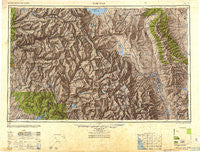
~ Mariposa CA topo map, 1:250000 scale, 1 X 2 Degree, Historical, 1947, updated 1948
Mariposa, California, USGS topographic map dated 1947.
Includes geographic coordinates (latitude and longitude). This topographic map is suitable for hiking, camping, and exploring, or framing it as a wall map.
Printed on-demand using high resolution imagery, on heavy weight and acid free paper, or alternatively on a variety of synthetic materials.
Topos available on paper, Waterproof, Poly, or Tyvek. Usually shipping rolled, unless combined with other folded maps in one order.
- Product Number: USGS-5630997
- Free digital map download (high-resolution, GeoPDF): Mariposa, California (file size: 14 MB)
- Map Size: please refer to the dimensions of the GeoPDF map above
- Weight (paper map): ca. 55 grams
- Map Type: POD USGS Topographic Map
- Map Series: HTMC
- Map Verison: Historical
- Cell ID: 68891
- Scan ID: 707463
- Imprint Year: 1948
- Woodland Tint: Yes
- Aerial Photo Year: 1945
- Datum: NAD27
- Map Projection: Transverse Mercator
- Shaded Relief map: Yes
- Map published by United States Army Corps of Engineers
- Map published by United States Army
- Map Language: English
- Scanner Resolution: 508 dpi
- Map Cell Name: Mariposa
- Grid size: 1 X 2 Degree
- Date on map: 1947
- Map Scale: 1:250000
- Geographical region: California, United States
Neighboring Maps:
All neighboring USGS topo maps are available for sale online at a variety of scales.
Spatial coverage:
Topo map Mariposa, California, covers the geographical area associated the following places:
- Whisky Falls - O'Neals - North Wawona (historical) - Glenwood Mobile Estates - Bishop Trail Park - Aspen Valley - Big Pine - Keough Hot Springs - Mathews Mill - Auberry - Darrah - Cedar Crest - White Wolf - Lakeshore - North Landing - Pineridge - Willow Glen (historical) - Mammoth Lakes - Bass Lake - Oneota (historical) - Fish Camp - New Auberry - Central Camp - Incline - Oakhurst - Clearing House - Sequoia - Yosemite Lakes - Huntington Lake - Bootjack - Crestview - Brockmans Corner - Poleta - Mono Hot Springs - Yosemite Forks - Tollhouse - Arlemont (historical) - Round Valley - Bass Lake Annex - Ben Hur - Elliott Corner - Bishop - Old Corral - Cascadel Woods - Shaver Lake Heights - Sunrise Mobile Home Park - Mariposa - Highlands Mobile Home Park - Montgomery City - Bailey Flats (historical) - Yosemite West - Old Bretz Mill - Toms Place - Raymond - Rocking K - Benton Hot Springs - J Diamond Trailer and Recreational Vehicle Park - Alder Springs - Dora Belle - Harden Flat - Yosemite Village - Foresta - Peterson Mill - South Wawona (historical) - Daulton - Snow Bend - Knowles - Rovana - Meadow Lakes - Bretz Mill - Dinkey Creek - Sierra Trailer Park - Chalfant Valley - North Fork - Buena Vista - Narbo (historical) - Lake Madera Country Estates - Mormon Bar - Benton - Sunland (historical) - Indian Lakes Estates - Mill City (historical) - Sierra Cedars - Lee Vining - Mono Mills - Bennettville (historical) - Gold Hit - Sugar Pine - Alta Vista - Mesa Camp - Genes Mobile Home Park - Wawona - Shaver Lake - Midpines - Benton Crossing - Fine Gold - Scheelite - Hildreth - Bley (historical) - Ahwahnee
- Map Area ID: AREA3837-120-118
- Northwest corner Lat/Long code: USGSNW38-120
- Northeast corner Lat/Long code: USGSNE38-118
- Southwest corner Lat/Long code: USGSSW37-120
- Southeast corner Lat/Long code: USGSSE37-118
- Northern map edge Latitude: 38
- Southern map edge Latitude: 37
- Western map edge Longitude: -120
- Eastern map edge Longitude: -118


