
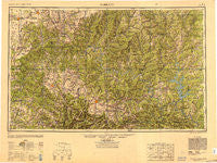
~ Harrison AR topo map, 1:250000 scale, 1 X 2 Degree, Historical, 1949, updated 1949
Harrison, Arkansas, USGS topographic map dated 1949.
Includes geographic coordinates (latitude and longitude). This topographic map is suitable for hiking, camping, and exploring, or framing it as a wall map.
Printed on-demand using high resolution imagery, on heavy weight and acid free paper, or alternatively on a variety of synthetic materials.
Topos available on paper, Waterproof, Poly, or Tyvek. Usually shipping rolled, unless combined with other folded maps in one order.
- Product Number: USGS-5630945
- Free digital map download (high-resolution, GeoPDF): Harrison, Arkansas (file size: 18 MB)
- Map Size: please refer to the dimensions of the GeoPDF map above
- Weight (paper map): ca. 55 grams
- Map Type: POD USGS Topographic Map
- Map Series: HTMC
- Map Verison: Historical
- Cell ID: 68816
- Scan ID: 707389
- Imprint Year: 1949
- Woodland Tint: Yes
- Aerial Photo Year: 1945
- Survey Year: 1946
- Datum: NAD27
- Map Projection: Transverse Mercator
- Shaded Relief map: Yes
- Map published by United States Army Corps of Engineers
- Map published by United States Army
- Map Language: English
- Scanner Resolution: 508 dpi
- Map Cell Name: Harrison
- Grid size: 1 X 2 Degree
- Date on map: 1949
- Map Scale: 1:250000
- Geographical region: Arkansas, United States
Neighboring Maps:
All neighboring USGS topo maps are available for sale online at a variety of scales.
Spatial coverage:
Topo map Harrison, Arkansas, covers the geographical area associated the following places:
- Burtonville - Arden - Wells Creek (historical) - Kingswood Estates - Dorcas (historical) - Trail - Iuka - Arkana - Marvel Cave - Hebron - Plumlee (historical) - Oak Mound - Capps - Spring Lake Estates - Holiday Island - Highlandville - Topaz - Cassville - Hill Top - Oak Ridge - Flippin - Exeter - Arno - Dogpatch - Dugginsville - Bakersfield - Ameera (historical) - Protem - Tomahawk - Dolph - Brixey - Jasper - Romance - Lone Rock - Willhoit - Laytonville (historical) - Freeman (historical) - Mante (historical) - Travers - Pottersville - Toccoa - Hercules - White City - Tecumseh - Mount Olive - Mallard Point - Watkins (historical) - Buckhart - Forum - Oregon (historical) - Yardelle - Flat Creek (historical) - Longrun - Comal - Verona - Ongo - Eagle Rock - Purdy - Bergman - Pleasant Ridge - Champion - Lakeway - Sycamore - Monkey Run - Althea - Pruitt - Irma - Lakeview - Eaudevie (historical) - Locust - Thuroy - Hopewell - Raum (historical) - Sycamore Spring - Tanglewood - Hilltop - Elijah - Conville (historical) - Edgewater Beach - Hale Crossing - Green Acres - Scholten - Keener - Evening Star - Jenkins - Nunnally (historical) - Richville - Boyle (historical) - Allfriend (historical) - Rippee (historical) - Hest - McClurg - Cedar Valley (historical) - Shady Grove - Blue Eye - Lakeland Hills - Heritage Estates - Glade - Big Flat - Crawford
- Map Area ID: AREA3736-94-92
- Northwest corner Lat/Long code: USGSNW37-94
- Northeast corner Lat/Long code: USGSNE37-92
- Southwest corner Lat/Long code: USGSSW36-94
- Southeast corner Lat/Long code: USGSSE36-92
- Northern map edge Latitude: 37
- Southern map edge Latitude: 36
- Western map edge Longitude: -94
- Eastern map edge Longitude: -92


