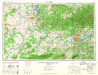
~ Fort Smith OK topo map, 1:250000 scale, 1 X 2 Degree, Historical, 1967
Fort Smith, Oklahoma, USGS topographic map dated 1967.
Includes geographic coordinates (latitude and longitude). This topographic map is suitable for hiking, camping, and exploring, or framing it as a wall map.
Printed on-demand using high resolution imagery, on heavy weight and acid free paper, or alternatively on a variety of synthetic materials.
Topos available on paper, Waterproof, Poly, or Tyvek. Usually shipping rolled, unless combined with other folded maps in one order.
- Product Number: USGS-5630939
- Free digital map download (high-resolution, GeoPDF): Fort Smith, Oklahoma (file size: 14 MB)
- Map Size: please refer to the dimensions of the GeoPDF map above
- Weight (paper map): ca. 55 grams
- Map Type: POD USGS Topographic Map
- Map Series: HTMC
- Map Verison: Historical
- Cell ID: 68785
- Scan ID: 802269
- Woodland Tint: Yes
- Aerial Photo Year: 1946
- Datum: NAD27
- Map Projection: Transverse Mercator
- Map published by United States Army Corps of Engineers
- Map published by United States Army
- Map Language: English
- Scanner Resolution: 508 dpi
- Map Cell Name: Fort Smith
- Grid size: 1 X 2 Degree
- Date on map: 1967
- Map Scale: 1:250000
- Geographical region: Oklahoma, United States
Neighboring Maps:
All neighboring USGS topo maps are available for sale online at a variety of scales.
Spatial coverage:
Topo map Fort Smith, Oklahoma, covers the geographical area associated the following places:
- Westville - Suttle - Fort Coffee - Greenwood - Excelsior - Oak Grove - Natural Dam - Welling - Bedwell - Tucker - Huntington - Barber - Vernon - Bloomer - Hanson - Bunch - Wainwright - Hyde Park - Porter - Cross Lanes - Banyard - Addielee - Riverdale - Concord - Van Buren - Saw Mill - Rosedale (historical) - Evening Shade - Fort Chaffee - Featherston - Stop (historical) - Barling - Canadian - Marble City - Grayson - Oak-Ta-Hah (historical) - Blocker - Murry Spur - Cartersville - Slaytonville - Ursula - Midland - Dutch Mills - Mount Gaylor - Canadian Shores - Kennady - Cedarville - Lancaster (historical) - Keys - Pettit - Cedar - Tahona - Stilwell - Brush Hill - Pocola - West Peavine - Hanna - Raiford - Maple - Wauhillau - Cain - Crossroads - Enterprise - Remy - Eldon - Wyola - Gilmore - Dayton - Alma - Strickler - Salem - Aqua Park - Mansfield - Rentiesville - Liberty - Warner - Stidham - Spiro - Winfrey - Locke - Brent - Poteau - Pinhook Corner - Greenwood - Evansville - Sanders - Milton - Mallard Bay - Onda - Keota - Artist Point - Yahola - Coalton - Copic Slab - Boynton - Zion - Arkola - Clarksville - White Bluff - Elm Park
- Map Area ID: AREA3635-96-94
- Northwest corner Lat/Long code: USGSNW36-96
- Northeast corner Lat/Long code: USGSNE36-94
- Southwest corner Lat/Long code: USGSSW35-96
- Southeast corner Lat/Long code: USGSSE35-94
- Northern map edge Latitude: 36
- Southern map edge Latitude: 35
- Western map edge Longitude: -96
- Eastern map edge Longitude: -94

