
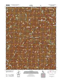
~ Ventana Cones CA topo map, 1:24000 scale, 7.5 X 7.5 Minute, Historical, 2012
Ventana Cones, California, USGS topographic map dated 2012.
Includes geographic coordinates (latitude and longitude). This topographic map is suitable for hiking, camping, and exploring, or framing it as a wall map.
Printed on-demand using high resolution imagery, on heavy weight and acid free paper, or alternatively on a variety of synthetic materials.
Topos available on paper, Waterproof, Poly, or Tyvek. Usually shipping rolled, unless combined with other folded maps in one order.
- Product Number: USGS-5629250
- Free digital map download (high-resolution, GeoPDF): Ventana Cones, California (file size: 27 MB)
- Map Size: please refer to the dimensions of the GeoPDF map above
- Weight (paper map): ca. 55 grams
- Map Type: POD USGS Topographic Map
- Map Series: US Topo
- Map Verison: Historical
- Cell ID: 46743
- Datum: North American Datum of 1983
- Map Projection: Transverse Mercator
- Map Cell Name: Ventana Cones
- Grid size: 7.5 X 7.5 Minute
- Date on map: 2012
- Map Scale: 1:24000
- Geographical region: California, United States
Neighboring Maps:
All neighboring USGS topo maps are available for sale online at a variety of scales.
Spatial coverage:
Topo map Ventana Cones, California, covers the geographical area associated the following places:
- Buckskin Flat Camp - Pine Ridge Trail - Hennicksons Ridge - Ventana Creek - Pine Falls - Sulphur Spring - Carmel River Camp - Round Rock Camp - Elephant Mountain - Puerto Suello Creek - Pine Valley Rustic Campsite - Dolores Creek - Sulpher Springs Camp - Hiding Canyon - Bluff Camp Recreation Site - Miller Fork Carmel River - Hennicksons Ridge Trail - Uncle Sam Mountain - Blue Creek - Miller Canyon Camp - Hiding Canyon Camp - Doolans Hole Creek - Ventana Cone - Bear Basin - Miller Canyon Rustic Campsite - Ventana Trail - Pine Ridge - Miller Mountain - Little Pines - Ventana Camp - Danish Creek - Miller Canyon - Rattlesnake Campground - Little Bear Trap - Carmel River Trail - Pine Valley - Ventana Double Cone - South Ventana Cone - Little Pines Camp - Pat Springs Camp - Ventana Mesa Creek - Bear Basin Creek - Pine Ridge Camp - Clover Basin Camp - Lion Creek - Redwood Creek Camp - Sulphur Springs Camp - Lone Pine Camp - Bear Basin Camp - Bruce Fork - Island Mountain
- Map Area ID: AREA36.37536.25-121.75-121.625
- Northwest corner Lat/Long code: USGSNW36.375-121.75
- Northeast corner Lat/Long code: USGSNE36.375-121.625
- Southwest corner Lat/Long code: USGSSW36.25-121.75
- Southeast corner Lat/Long code: USGSSE36.25-121.625
- Northern map edge Latitude: 36.375
- Southern map edge Latitude: 36.25
- Western map edge Longitude: -121.75
- Eastern map edge Longitude: -121.625


