
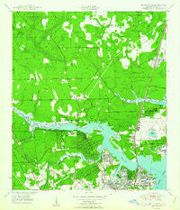
~ Trout River FL topo map, 1:24000 scale, 7.5 X 7.5 Minute, Historical, 1950
Trout River, Florida, USGS topographic map dated 1950.
Includes geographic coordinates (latitude and longitude). This topographic map is suitable for hiking, camping, and exploring, or framing it as a wall map.
Printed on-demand using high resolution imagery, on heavy weight and acid free paper, or alternatively on a variety of synthetic materials.
Topos available on paper, Waterproof, Poly, or Tyvek. Usually shipping rolled, unless combined with other folded maps in one order.
- Product Number: USGS-5628528
- Free digital map download (high-resolution, GeoPDF): Trout River, Florida (file size: 12 MB)
- Map Size: please refer to the dimensions of the GeoPDF map above
- Weight (paper map): ca. 55 grams
- Map Type: POD USGS Topographic Map
- Map Series: HTMC
- Map Verison: Historical
- Cell ID: 45753
- Scan ID: 348892
- Woodland Tint: Yes
- Edit Year: 1948
- Survey Year: 1948
- Datum: NAD27
- Map Projection: Polyconic
- Map published by United States Geological Survey
- Map published by United States Army Corps of Engineers
- Map Language: English
- Scanner Resolution: 600 dpi
- Map Cell Name: Trout River
- Grid size: 7.5 X 7.5 Minute
- Date on map: 1950
- Map Scale: 1:24000
- Geographical region: Florida, United States
Neighboring Maps:
All neighboring USGS topo maps are available for sale online at a variety of scales.
Spatial coverage:
Topo map Trout River, Florida, covers the geographical area associated the following places:
- Lake Forest Hills - Harbor View - Lake Forest Hills - Lake Forest - Oakhurst - Holly Ford - Northwood - Norwood - Biscayne Village - Beeghly Heights - Highlands - Trout River Mobile Home Park - Deloach Trailer Park - Oceanway - Briarwood Mobile Home Park - Carver Manor - Beverly Hills - Trailer Village Mobile Home Park - North Shore - Lake Park Estates - Sherwood Forest - Panama Park - Oaks Mobile Home Court - Lake Forest Manor - Shady Oak Mobile Home Park - Riverview - Magnolia Gardens - Dinsmore - Garden City - Ribault Manor - San Mateo
- Map Area ID: AREA30.530.375-81.75-81.625
- Northwest corner Lat/Long code: USGSNW30.5-81.75
- Northeast corner Lat/Long code: USGSNE30.5-81.625
- Southwest corner Lat/Long code: USGSSW30.375-81.75
- Southeast corner Lat/Long code: USGSSE30.375-81.625
- Northern map edge Latitude: 30.5
- Southern map edge Latitude: 30.375
- Western map edge Longitude: -81.75
- Eastern map edge Longitude: -81.625


