
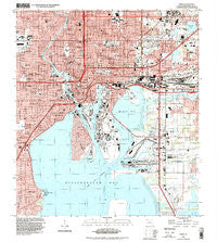
~ Tampa FL topo map, 1:24000 scale, 7.5 X 7.5 Minute, Historical, 1995, updated 1999
Tampa, Florida, USGS topographic map dated 1995.
Includes geographic coordinates (latitude and longitude). This topographic map is suitable for hiking, camping, and exploring, or framing it as a wall map.
Printed on-demand using high resolution imagery, on heavy weight and acid free paper, or alternatively on a variety of synthetic materials.
Topos available on paper, Waterproof, Poly, or Tyvek. Usually shipping rolled, unless combined with other folded maps in one order.
- Product Number: USGS-5628368
- Free digital map download (high-resolution, GeoPDF): Tampa, Florida (file size: 13 MB)
- Map Size: please refer to the dimensions of the GeoPDF map above
- Weight (paper map): ca. 55 grams
- Map Type: POD USGS Topographic Map
- Map Series: HTMC
- Map Verison: Historical
- Cell ID: 44262
- Scan ID: 348782
- Imprint Year: 1999
- Woodland Tint: Yes
- Aerial Photo Year: 1995
- Datum: NAD83
- Map Projection: Universal Transverse Mercator
- Map published by United States Geological Survey
- Map Language: English
- Scanner Resolution: 600 dpi
- Map Cell Name: Tampa
- Grid size: 7.5 X 7.5 Minute
- Date on map: 1995
- Map Scale: 1:24000
- Geographical region: Florida, United States
Neighboring Maps:
All neighboring USGS topo maps are available for sale online at a variety of scales.
Spatial coverage:
Topo map Tampa, Florida, covers the geographical area associated the following places:
- Riverside North - Western Heights - Lipscomb Villa - Oak Tree - Riverwoods - Irma - Berriman Place - Askew - Plymouth Court - Harbor View Palms - Murray - Park Place of East Tampa - Belmont Heights Estates - West Rosedale - West Pines - Strathmore - Post Harbour Island - Wagner Place - Lykes Estates - Southgreen - Devon Park - Oak Park Estates - Uceta Gardens - Azalea Gardens - Winton Park - Martindale Tourist Park - Jenkins - Dills - Wood Lynne - Maryland Avenue - Robles - Elizabeth - Rocky Shore - Rosemont Villa - Nebraska Heights South - Bayshore Court - Rhoda Lee - Knights Landing - Larchmont - West Suwanee Heights - Prospect Heights - Schley - College Heights - Marie - Bay View Estates - Lincoln Square - Marine Manor - Castillo Villa - Grant Park - Plainfield - Bunchville - Palm River Village - La Covadonga - Oakland - Hagle - Urbanrest - Chesterville Park - Packwood - Madsen Court - Grand View - Northview Hills - Eldorado - La Carbayera - Prince - Al Dana Park - Englewood - Gold Rush - Half Way Place - Golf View Park - Denis Place - Bayfair - Everett - Highland View - Funks Home Park - North Shore - Mar Cha Long - Lingerlong - West Bay Bluff - River Haven - Rainbow Heights - Habana Gardens North - Grant Place - West Arlington Heights - Cunningham - Bayshore Place - Altamira Heights - Terra Nova - Bonita - Matanzas - Eastern Heights - Bayshore Palms - Mills - Dixie - Centralia - Fendigs - Northview Terrace - Baya Vista - Vick - Oakridge - Highway Park
- Map Area ID: AREA2827.875-82.5-82.375
- Northwest corner Lat/Long code: USGSNW28-82.5
- Northeast corner Lat/Long code: USGSNE28-82.375
- Southwest corner Lat/Long code: USGSSW27.875-82.5
- Southeast corner Lat/Long code: USGSSE27.875-82.375
- Northern map edge Latitude: 28
- Southern map edge Latitude: 27.875
- Western map edge Longitude: -82.5
- Eastern map edge Longitude: -82.375


