
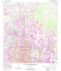
~ Sulphur Springs FL topo map, 1:24000 scale, 7.5 X 7.5 Minute, Historical, 1956, updated 1988
Sulphur Springs, Florida, USGS topographic map dated 1956.
Includes geographic coordinates (latitude and longitude). This topographic map is suitable for hiking, camping, and exploring, or framing it as a wall map.
Printed on-demand using high resolution imagery, on heavy weight and acid free paper, or alternatively on a variety of synthetic materials.
Topos available on paper, Waterproof, Poly, or Tyvek. Usually shipping rolled, unless combined with other folded maps in one order.
- Product Number: USGS-5628298
- Free digital map download (high-resolution, GeoPDF): Sulphur Springs, Florida (file size: 16 MB)
- Map Size: please refer to the dimensions of the GeoPDF map above
- Weight (paper map): ca. 55 grams
- Map Type: POD USGS Topographic Map
- Map Series: HTMC
- Map Verison: Historical
- Cell ID: 43701
- Scan ID: 348725
- Imprint Year: 1988
- Woodland Tint: Yes
- Photo Revision Year: 1987
- Aerial Photo Year: 1984
- Edit Year: 1987
- Survey Year: 1956
- Datum: NAD27
- Map Projection: Polyconic
- Map published by United States Geological Survey
- Map Language: English
- Scanner Resolution: 600 dpi
- Map Cell Name: Sulphur Springs
- Grid size: 7.5 X 7.5 Minute
- Date on map: 1956
- Map Scale: 1:24000
- Geographical region: Florida, United States
Neighboring Maps:
All neighboring USGS topo maps are available for sale online at a variety of scales.
Spatial coverage:
Topo map Sulphur Springs, Florida, covers the geographical area associated the following places:
- Linebaugh Estates - Lake Magdalene Park - Free Land Heights - Echols Lake Carroll Estates - Lin Lan Terrace - East End Place - Marco - Woodhaven - Sligh Avenue Estates - Lake Ellen - Fannypryde - Riverbend - Lake Carroll Court - Livingston Place - Prairie View Acres - Whitaker Estates - Lake Carroll Manor - Kathryn Park - Burnette Place - Fletchers Mill - Temple Knoll - Oak Springs - Otterman - Forest Hills - Habana Heights - Idlewild on the Hillsborough - Carrollton Lakes - Eva Egla Terrace - Royal Greens - Castillo - Tampa Overlook - Lake Gass Estates - Lake Magdalene Arms - Lake Ellen Villas - Oaks at Riverview - Golfland Park - Durolife Homes - Crawford Place - Sylvan Dale - Heatherton Heights - Edwards - Fairview Terrace - Lawrence - Leonard Terrace - Azure Estates - Hillcrest Acres - Parkview Estates - Greenmoor - Lake Forest - Walker Heights - Jones Estates - Georgia Terrace - Gilberts - Hillsboro Highlands - Little Henry - Sherwood Heights - Sandy Ridge - Sico - Unity Circle - Ballard Park - Temple Bluff - Banner Oaks - Harris Branch - Burnes Lake Estates - Twin Lakes Estates - Tawesco Heights - Gay Villa Farms - North Pointe - The Arbors - Delmar Terrace - Auburn Highlands - River Highlands - Daneli - Lake Magdalene Forest - North Tampa Heights - Norris - University Square - Byrd Lake Woods - Lorene Terrace - Brompton Place - Magdalene Grove - Poinsettia Park - Grandview Acres - Sutton Place - The Estates at White Trout Lake - Herrera - Pine Lake - Ayalas Grove - Hill Top Heights - Jackson Court - Kenilworth Grove - Twin Lake Terrace - Angelina Pines - Claonia Highlands - Valencia Manor - Puritan Heights - Duque Road - Flora Park - Hampton Place - Rivershore Oaks
- Map Area ID: AREA28.12528-82.5-82.375
- Northwest corner Lat/Long code: USGSNW28.125-82.5
- Northeast corner Lat/Long code: USGSNE28.125-82.375
- Southwest corner Lat/Long code: USGSSW28-82.5
- Southeast corner Lat/Long code: USGSSE28-82.375
- Northern map edge Latitude: 28.125
- Southern map edge Latitude: 28
- Western map edge Longitude: -82.5
- Eastern map edge Longitude: -82.375


