
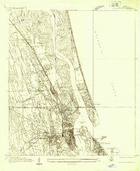
~ St Augustine FL topo map, 1:24000 scale, 7.5 X 7.5 Minute, Historical, 1937
St Augustine, Florida, USGS topographic map dated 1937.
Includes geographic coordinates (latitude and longitude). This topographic map is suitable for hiking, camping, and exploring, or framing it as a wall map.
Printed on-demand using high resolution imagery, on heavy weight and acid free paper, or alternatively on a variety of synthetic materials.
Topos available on paper, Waterproof, Poly, or Tyvek. Usually shipping rolled, unless combined with other folded maps in one order.
- Product Number: USGS-5628194
- Free digital map download (high-resolution, GeoPDF): St Augustine, Florida (file size: 9 MB)
- Map Size: please refer to the dimensions of the GeoPDF map above
- Weight (paper map): ca. 55 grams
- Map Type: POD USGS Topographic Map
- Map Series: HTMC
- Map Verison: Historical
- Cell ID: 39223
- Scan ID: 348683
- Survey Year: 1937
- Datum: NAD27
- Map Projection: Polyconic
- Advance: Yes
- Map published by United States Geological Survey
- Keywords: Nonstandard Press Run
- Map Language: English
- Scanner Resolution: 600 dpi
- Map Cell Name: Saint Augustine
- Grid size: 7.5 X 7.5 Minute
- Date on map: 1937
- Map Scale: 1:24000
- Geographical region: Florida, United States
Neighboring Maps:
All neighboring USGS topo maps are available for sale online at a variety of scales.
Spatial coverage:
Topo map St Augustine, Florida, covers the geographical area associated the following places:
- El Rey Residential Court - Anastasia - Newt's Trailer Park - Frog Hollow Court Mobile Home Park - Siesta Mobile Home Park - Vilano Beach - Brentwood Mobile Home Park - Araquey - Lazy C Mobile Home Park - Villano Beach - Moultrie Junction - Dobbs Mobile Home Park - College Park - Nombre de Dios (historical) - Breeze Trailer Park - Usina Beach - Shady Pines II Mobile Home Park - Graceland Mobile Home Park - Woodlawn - Casa Cola - Saint Augustine Family Park Mobile Home Park - Seven Pines Mobile Home Park - Kingsley Mobile Home Park - Bernards Trailer Park - Saint Augustine - Coquina Oaks Mobile Home - Gaines Mobile Home Park - Davis Shores
- Map Area ID: AREA3029.875-81.375-81.25
- Northwest corner Lat/Long code: USGSNW30-81.375
- Northeast corner Lat/Long code: USGSNE30-81.25
- Southwest corner Lat/Long code: USGSSW29.875-81.375
- Southeast corner Lat/Long code: USGSSE29.875-81.25
- Northern map edge Latitude: 30
- Southern map edge Latitude: 29.875
- Western map edge Longitude: -81.375
- Eastern map edge Longitude: -81.25


