
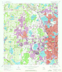
~ Orlando West FL topo map, 1:24000 scale, 7.5 X 7.5 Minute, Historical, 1956, updated 1972
Orlando West, Florida, USGS topographic map dated 1956.
Includes geographic coordinates (latitude and longitude). This topographic map is suitable for hiking, camping, and exploring, or framing it as a wall map.
Printed on-demand using high resolution imagery, on heavy weight and acid free paper, or alternatively on a variety of synthetic materials.
Topos available on paper, Waterproof, Poly, or Tyvek. Usually shipping rolled, unless combined with other folded maps in one order.
- Product Number: USGS-5626936
- Free digital map download (high-resolution, GeoPDF): Orlando West, Florida (file size: 15 MB)
- Map Size: please refer to the dimensions of the GeoPDF map above
- Weight (paper map): ca. 55 grams
- Map Type: POD USGS Topographic Map
- Map Series: HTMC
- Map Verison: Historical
- Cell ID: 33439
- Scan ID: 347874
- Imprint Year: 1972
- Woodland Tint: Yes
- Photo Revision Year: 1970
- Aerial Photo Year: 1970
- Field Check Year: 1956
- Datum: NAD27
- Map Projection: Polyconic
- Map published by United States Geological Survey
- Map Language: English
- Scanner Resolution: 600 dpi
- Map Cell Name: Orlando West
- Grid size: 7.5 X 7.5 Minute
- Date on map: 1956
- Map Scale: 1:24000
- Geographical region: Florida, United States
Neighboring Maps:
All neighboring USGS topo maps are available for sale online at a variety of scales.
Spatial coverage:
Topo map Orlando West, Florida, covers the geographical area associated the following places:
- Groves Mobile Home Community - South Orange Mobile Home Park - Fairview Mobile Court - Whispering Palms Mobile Home Park - Fairview Shores - The Groves Mobile Home Park - Sabal Palm Mobile Home Park - Fairvilla Court Mobile Home Park - Cozy Cove Mobile Home Park - Orlovista - Town and Country Mobile Home Park - Clarcona - Palamar Trailer Park - Lakeshore Landings Mobile Home Park - Magnolia Mobile Home Park - Grand Avenue Trailer Park - Rosemont - Lockhart Mobile Home Park - Camino Park Mobile Home Park - Silver Star Village Mobile Home Park - Conestoga Mobile Home Park - Lockhart - Orlando - Eatonville - Pine Hills - Marsh's Trailer Park - Lake Shore Village Mobile Home Park - El Punto Lake Mobile Home Park - Fairvilla - Oak Crest Mobile Park - Palms Trailer Park - Sandy Shores Mobile Home Park - Sunset Park Mobile Home Park
- Map Area ID: AREA28.62528.5-81.5-81.375
- Northwest corner Lat/Long code: USGSNW28.625-81.5
- Northeast corner Lat/Long code: USGSNE28.625-81.375
- Southwest corner Lat/Long code: USGSSW28.5-81.5
- Southeast corner Lat/Long code: USGSSE28.5-81.375
- Northern map edge Latitude: 28.625
- Southern map edge Latitude: 28.5
- Western map edge Longitude: -81.5
- Eastern map edge Longitude: -81.375


