
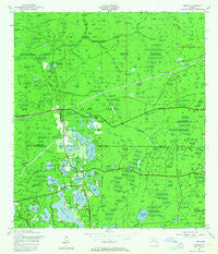
~ Odessa FL topo map, 1:24000 scale, 7.5 X 7.5 Minute, Historical, 1943, updated 1964
Odessa, Florida, USGS topographic map dated 1943.
Includes geographic coordinates (latitude and longitude). This topographic map is suitable for hiking, camping, and exploring, or framing it as a wall map.
Printed on-demand using high resolution imagery, on heavy weight and acid free paper, or alternatively on a variety of synthetic materials.
Topos available on paper, Waterproof, Poly, or Tyvek. Usually shipping rolled, unless combined with other folded maps in one order.
- Product Number: USGS-5626730
- Free digital map download (high-resolution, GeoPDF): Odessa, Florida (file size: 10 MB)
- Map Size: please refer to the dimensions of the GeoPDF map above
- Weight (paper map): ca. 55 grams
- Map Type: POD USGS Topographic Map
- Map Series: HTMC
- Map Verison: Historical
- Cell ID: 32919
- Scan ID: 347749
- Imprint Year: 1964
- Woodland Tint: Yes
- Survey Year: 1943
- Datum: NAD27
- Map Projection: Polyconic
- Map published by United States Geological Survey
- Map published by United States Army Corps of Engineers
- Map published by United States Army
- Map Language: English
- Scanner Resolution: 600 dpi
- Map Cell Name: Odessa
- Grid size: 7.5 X 7.5 Minute
- Date on map: 1943
- Map Scale: 1:24000
- Geographical region: Florida, United States
Neighboring Maps:
All neighboring USGS topo maps are available for sale online at a variety of scales.
Spatial coverage:
Topo map Odessa, Florida, covers the geographical area associated the following places:
- Bayonnes at Cheval - Calusa Trace - Lake Alice Estates - Van Dyke Estates - Keystone Estates - Cheval Wimbledon Village - Angel Farms Estates - Keystone Terrace - Lakes of Keystone - Trezevant - Wyndham Lakes - Ridgeland - Post Shores - Lake Calm Estates - Rankin Acres - Cimino Estates - Keystone Lake View Park - Lady Lake Estates - Keystone Park Colony - C And B Estates - Lake Calm - Heritage Harbor Village - Odessa Woods - The Cove at Lake Alice - Cannes Village - Reflections - The Meadows at Van Dyke Farms - Cheval Lake Club Villas - Stillwater - Odessa - Estates of Lake Alice - Gulf Pine - Keystone Reserve - Heritage Harbor - Keystone Manor - Keystone - Canterbury Woods - Keystone Farms - Cheval East Bordeaux - Cypress Lake Estates - Cheval - Clarkmere - Keystone Shores - Swan Cove - Island Ford Lake Beach - Fern Glen - Belmack Acres - Montreux - Crippenwood - Shapiro - Lake Fern - Great Lakes - Keystone Grove Lakes - Lindawoods - Keystone Beach - Biarritz Village - The Nest - Zambito Estates - Daly - Lakeview at Calusa Trace - Cheval Boulevard Estates West - Keystone Cove - Alldredge - Chateaux Loire - Cheval Boulevard Estates East - Lake Abray - Beau Rivage - Council Crest
- Map Area ID: AREA28.2528.125-82.625-82.5
- Northwest corner Lat/Long code: USGSNW28.25-82.625
- Northeast corner Lat/Long code: USGSNE28.25-82.5
- Southwest corner Lat/Long code: USGSSW28.125-82.625
- Southeast corner Lat/Long code: USGSSE28.125-82.5
- Northern map edge Latitude: 28.25
- Southern map edge Latitude: 28.125
- Western map edge Longitude: -82.625
- Eastern map edge Longitude: -82.5


