
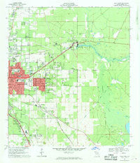
~ Ocala East FL topo map, 1:24000 scale, 7.5 X 7.5 Minute, Historical, 1967, updated 1969
Ocala East, Florida, USGS topographic map dated 1967.
Includes geographic coordinates (latitude and longitude). This topographic map is suitable for hiking, camping, and exploring, or framing it as a wall map.
Printed on-demand using high resolution imagery, on heavy weight and acid free paper, or alternatively on a variety of synthetic materials.
Topos available on paper, Waterproof, Poly, or Tyvek. Usually shipping rolled, unless combined with other folded maps in one order.
- Product Number: USGS-5626712
- Free digital map download (high-resolution, GeoPDF): Ocala East, Florida (file size: 10 MB)
- Map Size: please refer to the dimensions of the GeoPDF map above
- Weight (paper map): ca. 55 grams
- Map Type: POD USGS Topographic Map
- Map Series: HTMC
- Map Verison: Historical
- Cell ID: 32858
- Scan ID: 347738
- Imprint Year: 1969
- Woodland Tint: Yes
- Aerial Photo Year: 1964
- Field Check Year: 1967
- Datum: NAD27
- Map Projection: Polyconic
- Map published by United States Geological Survey
- Map Language: English
- Scanner Resolution: 600 dpi
- Map Cell Name: Ocala East
- Grid size: 7.5 X 7.5 Minute
- Date on map: 1967
- Map Scale: 1:24000
- Geographical region: Florida, United States
Neighboring Maps:
All neighboring USGS topo maps are available for sale online at a variety of scales.
Spatial coverage:
Topo map Ocala East, Florida, covers the geographical area associated the following places:
- Montague - Cherry Hill Mobile Home Park - Blue Skies Estates Mobile Home Park - Maricamp - Rolling Greens Mobile Home Park - Arbors of Ocala Mobile Home Park - Silver Springs - Wagon Wheel Mobile Home Park - Craft Travel Trailer Park - Twin Oaks Mobile Home Park - Camp Roosevelt - Nautilus Trailer Park - Cala Springs Mobile Home Park - Huntington - Spanish Palm Estates Mobile Home Park - Country Aire Mobile Home Park - Lindale Mobile Home Park - Southeast Side Mobile Home Park - Spanish Oaks Mobile Home Park
- Map Area ID: AREA29.2529.125-82.125-82
- Northwest corner Lat/Long code: USGSNW29.25-82.125
- Northeast corner Lat/Long code: USGSNE29.25-82
- Southwest corner Lat/Long code: USGSSW29.125-82.125
- Southeast corner Lat/Long code: USGSSE29.125-82
- Northern map edge Latitude: 29.25
- Southern map edge Latitude: 29.125
- Western map edge Longitude: -82.125
- Eastern map edge Longitude: -82


