
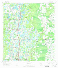
~ Lutz FL topo map, 1:24000 scale, 7.5 X 7.5 Minute, Historical, 1943, updated 1961
Lutz, Florida, USGS topographic map dated 1943.
Includes geographic coordinates (latitude and longitude). This topographic map is suitable for hiking, camping, and exploring, or framing it as a wall map.
Printed on-demand using high resolution imagery, on heavy weight and acid free paper, or alternatively on a variety of synthetic materials.
Topos available on paper, Waterproof, Poly, or Tyvek. Usually shipping rolled, unless combined with other folded maps in one order.
- Product Number: USGS-5626030
- Free digital map download (high-resolution, GeoPDF): Lutz, Florida (file size: 10 MB)
- Map Size: please refer to the dimensions of the GeoPDF map above
- Weight (paper map): ca. 55 grams
- Map Type: POD USGS Topographic Map
- Map Series: HTMC
- Map Verison: Historical
- Cell ID: 26987
- Scan ID: 347291
- Imprint Year: 1961
- Woodland Tint: Yes
- Visual Version Number: 1
- Aerial Photo Year: 1942
- Survey Year: 1943
- Datum: NAD27
- Map Projection: Polyconic
- Map published by United States Geological Survey
- Map Language: English
- Scanner Resolution: 600 dpi
- Map Cell Name: Lutz
- Grid size: 7.5 X 7.5 Minute
- Date on map: 1943
- Map Scale: 1:24000
- Geographical region: Florida, United States
Neighboring Maps:
All neighboring USGS topo maps are available for sale online at a variety of scales.
Spatial coverage:
Topo map Lutz, Florida, covers the geographical area associated the following places:
- Ridgelake - Grand Hampton - Holly Lake Estates - Bonniebrook Estates - Dupree Gardens - Lake Kell Crossings - Sanctuary on Livingston - Lake Sapphire Estates - Blessed Estates - Rosa Acres - Oaks at Windemere - Sherry Brook Estates - Ballinger Estates - Garden Grove - Camphor Cove - San Remo - Sherry Brook Lane - Crystal Acres - Wellington Manors - Kingsborough Gardens - Frazier - Coventry - Karavas Estates - Hanna Pond Country Estates - Carr Drive - Willow Creek - Marilyn Shores - Holly Lane - Crystal Lakes View - Lake Fern Villas - Kauchick Estates - Rustic Oaks Place - Wellington Manor - Puleo Estates - Kensington Estates - Stemper Terrace - Candlelight - Crilly Acres - Suydam - Montana Pines - Heather Manor - Southern Acres - Sapphire Lake Ranchitos - Villa Roma - Oak Path - Sunset Lane Park - Tangerine Hill - Newberger Pines - Windemere - Deer Park - Coopers Pond - Stonehenge Estates - Willow Pond - Killen Estates - Ziegler Brothers Estates - Turning Point - Lake Cooper Woods - Lake Brooker North - Lake Brooker Village - Lake Norbert Fuller - Bruing - Stewart Manor - Family Woods Estates - East North Tampa - Country Oaks - Eden Acres - Pine Crest Estates - Lutz Lake - Coopers Bayou - Evergreen North - Drexel - Cullaro - West North Tampa - Warrington Green - Lake Thomas Estates - Popes - Shady Lake Shores - Sunlake Park - Lake Keen Estates - Eagle Crest - Lakes of Wellington - Sunny Pines - Surrey Chase - Crystal Cove - Lake Keen - Suzie Trace - Keeters - Rhoades Wood Acres - Keene Lake Manors - Land O' Lakes - Jessies Place - Tracers Lake Keen Estates - Sapphire Lake - Yocam Village - Fox Run - Rainforest East - Mobilaire - Lake Brooker South - Shephards Cove - Cypress Cove
- Map Area ID: AREA28.2528.125-82.5-82.375
- Northwest corner Lat/Long code: USGSNW28.25-82.5
- Northeast corner Lat/Long code: USGSNE28.25-82.375
- Southwest corner Lat/Long code: USGSSW28.125-82.5
- Southeast corner Lat/Long code: USGSSE28.125-82.375
- Northern map edge Latitude: 28.25
- Southern map edge Latitude: 28.125
- Western map edge Longitude: -82.5
- Eastern map edge Longitude: -82.375


