
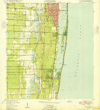
~ Lake Worth FL topo map, 1:24000 scale, 7.5 X 7.5 Minute, Historical, 1949, updated 1949
Lake Worth, Florida, USGS topographic map dated 1949.
Includes geographic coordinates (latitude and longitude). This topographic map is suitable for hiking, camping, and exploring, or framing it as a wall map.
Printed on-demand using high resolution imagery, on heavy weight and acid free paper, or alternatively on a variety of synthetic materials.
Topos available on paper, Waterproof, Poly, or Tyvek. Usually shipping rolled, unless combined with other folded maps in one order.
- Product Number: USGS-5625800
- Free digital map download (high-resolution, GeoPDF): Lake Worth, Florida (file size: 9 MB)
- Map Size: please refer to the dimensions of the GeoPDF map above
- Weight (paper map): ca. 55 grams
- Map Type: POD USGS Topographic Map
- Map Series: HTMC
- Map Verison: Historical
- Cell ID: 24721
- Scan ID: 347158
- Imprint Year: 1949
- Woodland Tint: Yes
- Aerial Photo Year: 1945
- Datum: NAD27
- Map Projection: Polyconic
- Map published by United States Geological Survey
- Map published by United States Department of Commerce
- Map Language: English
- Scanner Resolution: 600 dpi
- Map Cell Name: Lake Worth
- Grid size: 7.5 X 7.5 Minute
- Date on map: 1949
- Map Scale: 1:24000
- Geographical region: Florida, United States
Neighboring Maps:
All neighboring USGS topo maps are available for sale online at a variety of scales.
Spatial coverage:
Topo map Lake Worth, Florida, covers the geographical area associated the following places:
- Briny Breezes - Palm Breezes Club Mobile Home Park - Tropical Gardens Trailer Park - Royal Manor Mobile Home Estates - Kokomo Mobile Home Park - Hypoluxo Village - Hometown Whispering Pines Mobile Home Park - Sunny South Estates Mobile Home Park - Orange Grove Mobile Home Park - Hypoluxo - Seminole Manor - Palm Beach Mobile Home Park - Lake Osborne Trailer Ranch - Mar Mak Mobile Leisureville Mobile Home Park - Coopers Mobile Village - Sand and Sea Village Mobile Home Park - Maralago Cay of West Palm Beach Mobile Home Park - Jamaica Bay Mobile Home Park - Lantana - South Palm Beach - Boynton Beach - Toms Trailer Park - Lake Worth - Lantana Cascade Mobile Home Park - Manalapan - Holiday Mobile Home Park - Melaleuca Trailer Park - Pine Needle Mobile Home Park - Grasso Mobile Home Park - Whispering Pines Mobile Home Park - Country Club Trail - Atlantis - Tropical Trailer Gardens - La Paloma Community Mobile Home Park - Ocean Ridge - Royal Palm Mobile Home Park
- Map Area ID: AREA26.62526.5-80.125-80
- Northwest corner Lat/Long code: USGSNW26.625-80.125
- Northeast corner Lat/Long code: USGSNE26.625-80
- Southwest corner Lat/Long code: USGSSW26.5-80.125
- Southeast corner Lat/Long code: USGSSE26.5-80
- Northern map edge Latitude: 26.625
- Southern map edge Latitude: 26.5
- Western map edge Longitude: -80.125
- Eastern map edge Longitude: -80


