
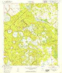
~ Gold Head Branch FL topo map, 1:24000 scale, 7.5 X 7.5 Minute, Historical, 1949, updated 1953
Gold Head Branch, Florida, USGS topographic map dated 1949.
Includes geographic coordinates (latitude and longitude). This topographic map is suitable for hiking, camping, and exploring, or framing it as a wall map.
Printed on-demand using high resolution imagery, on heavy weight and acid free paper, or alternatively on a variety of synthetic materials.
Topos available on paper, Waterproof, Poly, or Tyvek. Usually shipping rolled, unless combined with other folded maps in one order.
- Product Number: USGS-5624620
- Free digital map download (high-resolution, GeoPDF): Gold Head Branch, Florida (file size: 10 MB)
- Map Size: please refer to the dimensions of the GeoPDF map above
- Weight (paper map): ca. 55 grams
- Map Type: POD USGS Topographic Map
- Map Series: HTMC
- Map Verison: Historical
- Cell ID: 17589
- Scan ID: 346453
- Imprint Year: 1953
- Woodland Tint: Yes
- Aerial Photo Year: 1947
- Field Check Year: 1949
- Datum: NAD27
- Map Projection: Polyconic
- Map published by United States Geological Survey
- Map published by United States Army Corps of Engineers
- Map published by United States Army
- Map Language: English
- Scanner Resolution: 600 dpi
- Map Cell Name: Gold Head Branch
- Grid size: 7.5 X 7.5 Minute
- Date on map: 1949
- Map Scale: 1:24000
- Geographical region: Florida, United States
Neighboring Maps:
All neighboring USGS topo maps are available for sale online at a variety of scales.
Spatial coverage:
Topo map Gold Head Branch, Florida, covers the geographical area associated the following places:
- Winding Tree Lake - Silver Sand Lake - Little Lake Johnson - Abundant Life Church - Mike Roess Gold Head Branch State Park - Spring Lake - Bull Pond - Gold Head Branch - Coopers Pond - Pear Lake - M Lake - Smith Lake - Oldfield Pond - Lake Hill Baptist Church - Gadara Cemetery - Pebble Lake - Lake Margie - Sheelar Lake - Bundy Lake - Lake Hill Baptist Church - McRae Volunteer Fire Department - Flower Prairie - Gator Bone Lake - McRae Elementary School - Devils Wash Basin - Goldhead American Tower - Twin Lakes - Gadara Baptist Church - Big Lake Johnson - Long Lake - Hall Lake - White Sands Lake - Lake Washington
- Map Area ID: AREA29.87529.75-82-81.875
- Northwest corner Lat/Long code: USGSNW29.875-82
- Northeast corner Lat/Long code: USGSNE29.875-81.875
- Southwest corner Lat/Long code: USGSSW29.75-82
- Southeast corner Lat/Long code: USGSSE29.75-81.875
- Northern map edge Latitude: 29.875
- Southern map edge Latitude: 29.75
- Western map edge Longitude: -82
- Eastern map edge Longitude: -81.875


