
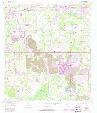
~ Dover FL topo map, 1:24000 scale, 7.5 X 7.5 Minute, Historical, 1955, updated 1987
Dover, Florida, USGS topographic map dated 1955.
Includes geographic coordinates (latitude and longitude). This topographic map is suitable for hiking, camping, and exploring, or framing it as a wall map.
Printed on-demand using high resolution imagery, on heavy weight and acid free paper, or alternatively on a variety of synthetic materials.
Topos available on paper, Waterproof, Poly, or Tyvek. Usually shipping rolled, unless combined with other folded maps in one order.
- Product Number: USGS-5623610
- Free digital map download (high-resolution, GeoPDF): Dover, Florida (file size: 12 MB)
- Map Size: please refer to the dimensions of the GeoPDF map above
- Weight (paper map): ca. 55 grams
- Map Type: POD USGS Topographic Map
- Map Series: HTMC
- Map Verison: Historical
- Cell ID: 12691
- Scan ID: 345871
- Imprint Year: 1987
- Woodland Tint: Yes
- Photo Revision Year: 1987
- Aerial Photo Year: 1947
- Edit Year: 1987
- Survey Year: 1955
- Datum: NAD27
- Map Projection: Polyconic
- Map published by United States Geological Survey
- Map Language: English
- Scanner Resolution: 600 dpi
- Map Cell Name: Dover
- Grid size: 7.5 X 7.5 Minute
- Date on map: 1955
- Map Scale: 1:24000
- Geographical region: Florida, United States
Neighboring Maps:
All neighboring USGS topo maps are available for sale online at a variety of scales.
Spatial coverage:
Topo map Dover, Florida, covers the geographical area associated the following places:
- Marlyn Manor - Kaylas Cove - Suncrest Estates - Innergary Point - Doris Coats Acres - Delgado - Twin Oaks - Olympus Acres - McDonald-Slone Estates - Sosa Estates - Lumsden Trace - Lehman Acres - Turkey Creek Acres - Redd - Country Gate - Toole Place - Carriage Park - Chelsea Woods - Harder Oaks - Ruffin Acres - Buckingham - Waller Acres - Puntkins Patch - Brandon Valrico Hills Estates - Valrico Groves - Westminster - Pleasant Grove Acres - Lithia Ridge - Bent Tree Estates - Trapnell Ridge - Copper Ridge - Pine Dale Estates - Eaglewood Estates - Isabel Estates - Mulrennan Groves North - Saint Cloud Manor - Dover Oaks - Davis Acres - Indian Trails - Saint Cloud Reserve - Oaklane Estates - Miller Woods - Tevalo Hills - Walden Lake Fairway Villas - Reynoso - Raulerson Estates South - Melouga Preserve - Puntkins Place - Lone Oak Grove - Trails at Durant - The Dryden Estates - Bingham - Marvinia Hills - Alice Winter Gardens - Winter Estates - Sydney - Lone Oak Haven - Diamond Hill - Leonard - Eastmonte - McIntosh Lakes - Jerrys - Canterbury Oaks - Kings Mill - Buckhorn Hills - Woodfield Village - Fleites Acres - Tract 80 Estates - Legends Pass - Drakes Place - Delarua - Buckhorn Trace - Eastwood Glenn - The Paddocks - Springdell Estates - Walden Lake Fairway Estates - Saint Cloud Oaks - Mulrennan Estates - High Country Acres - Durant Woods - Citrus Wood - Connell Groves - Popago Estates - Leighton Acres - Brown Estates - Canter - Durant - Heritage Crest - Greenhills - Ashley Estates - Pineapple Hill - Ashbrook - Dover Park - Medley Manor - Sidney Highlands - Sydney Crossings - Graves Orchard - Margaline Gardens - Arista - Shupard Estates
- Map Area ID: AREA2827.875-82.25-82.125
- Northwest corner Lat/Long code: USGSNW28-82.25
- Northeast corner Lat/Long code: USGSNE28-82.125
- Southwest corner Lat/Long code: USGSSW27.875-82.25
- Southeast corner Lat/Long code: USGSSE27.875-82.125
- Northern map edge Latitude: 28
- Southern map edge Latitude: 27.875
- Western map edge Longitude: -82.25
- Eastern map edge Longitude: -82.125


