
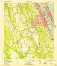
~ Daytona Beach FL topo map, 1:24000 scale, 7.5 X 7.5 Minute, Historical, 1952, updated 1956
Daytona Beach, Florida, USGS topographic map dated 1952.
Includes geographic coordinates (latitude and longitude). This topographic map is suitable for hiking, camping, and exploring, or framing it as a wall map.
Printed on-demand using high resolution imagery, on heavy weight and acid free paper, or alternatively on a variety of synthetic materials.
Topos available on paper, Waterproof, Poly, or Tyvek. Usually shipping rolled, unless combined with other folded maps in one order.
- Product Number: USGS-5623422
- Free digital map download (high-resolution, GeoPDF): Daytona Beach, Florida (file size: 11 MB)
- Map Size: please refer to the dimensions of the GeoPDF map above
- Weight (paper map): ca. 55 grams
- Map Type: POD USGS Topographic Map
- Map Series: HTMC
- Map Verison: Historical
- Cell ID: 11505
- Scan ID: 345749
- Imprint Year: 1956
- Woodland Tint: Yes
- Aerial Photo Year: 1951
- Field Check Year: 1952
- Survey Year: 1951
- Datum: NAD27
- Map Projection: Polyconic
- Map published by United States Geological Survey
- Map published by United States Army Corps of Engineers
- Map Language: English
- Scanner Resolution: 600 dpi
- Map Cell Name: Daytona Beach
- Grid size: 7.5 X 7.5 Minute
- Date on map: 1952
- Map Scale: 1:24000
- Geographical region: Florida, United States
Neighboring Maps:
All neighboring USGS topo maps are available for sale online at a variety of scales.
Spatial coverage:
Topo map Daytona Beach, Florida, covers the geographical area associated the following places:
- Carriage Cove Mobile Home Park - Gray Acres Mobile Home Park - Daytona Twin Oaks Mobile Home Park - Lamplighter Mobile Home Community - Robin Hood Terrace Mobile Home Park - Royal Oak Trailer Park - Colonial Colony South Mobile Home Park - Lighthouse Pointe at Daytona Beach Mobile Home Park - Daytona Beach - Blake - June Terrace Mobile Home Park - Colonial Colony North Mobile Home Park - Iowa Trailer Park - Colony in the Wood Mobile Home Park - Hillside Trailer Park - Ra Mar Mobile Home Park - Candlelight Manor Mobile Home Estates - Mansfield Mobile Home Park - Lakeview Estates Mobile Home Park - Sherwood Del Mobile Home Park - Ashland Mobile Home Park - Elmwood Mobile Home Park - Shady Village Mobile Home Park - South Daytona - Pickwick Village - Holly Hill - Holly Forest Estates Mobile Home Park - Cozy Circle Trailer Park - Seabreeze - Reed Canal Trailer Park - Lacosta Village Mobile Home Park - Blue Villa Mobile Home Park
- Map Area ID: AREA29.2529.125-81.125-81
- Northwest corner Lat/Long code: USGSNW29.25-81.125
- Northeast corner Lat/Long code: USGSNE29.25-81
- Southwest corner Lat/Long code: USGSSW29.125-81.125
- Southeast corner Lat/Long code: USGSSE29.125-81
- Northern map edge Latitude: 29.25
- Southern map edge Latitude: 29.125
- Western map edge Longitude: -81.125
- Eastern map edge Longitude: -81


