
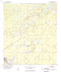
~ Cross City East FL topo map, 1:24000 scale, 7.5 X 7.5 Minute, Historical, 1954, updated 1955
Cross City East, Florida, USGS topographic map dated 1954.
Includes geographic coordinates (latitude and longitude). This topographic map is suitable for hiking, camping, and exploring, or framing it as a wall map.
Printed on-demand using high resolution imagery, on heavy weight and acid free paper, or alternatively on a variety of synthetic materials.
Topos available on paper, Waterproof, Poly, or Tyvek. Usually shipping rolled, unless combined with other folded maps in one order.
- Product Number: USGS-5623304
- Free digital map download (high-resolution, GeoPDF): Cross City East, Florida (file size: 9 MB)
- Map Size: please refer to the dimensions of the GeoPDF map above
- Weight (paper map): ca. 55 grams
- Map Type: POD USGS Topographic Map
- Map Series: HTMC
- Map Verison: Historical
- Cell ID: 10813
- Scan ID: 345694
- Imprint Year: 1955
- Woodland Tint: Yes
- Visual Version Number: 1
- Aerial Photo Year: 1952
- Survey Year: 1954
- Datum: NAD27
- Map Projection: Polyconic
- Map published by United States Geological Survey
- Map Language: English
- Scanner Resolution: 600 dpi
- Map Cell Name: Cross City East
- Grid size: 7.5 X 7.5 Minute
- Date on map: 1954
- Map Scale: 1:24000
- Geographical region: Florida, United States
Neighboring Maps:
All neighboring USGS topo maps are available for sale online at a variety of scales.
Spatial coverage:
Topo map Cross City East, Florida, covers the geographical area associated the following places:
- Dixie County Emergency Medical Services Station 1 - Dixie County Sheriff's Office - Sand Pond - Cross City Airport - Cross City Correctional Institution Library - Bodiford Pond - Cross City Correctional Institution - Cross City Post Office - Dixie County Fire and Rescue Station 41 - Delaney Prairie - Ocean Pond - Holly Hill Lookout Tower - Adams Lake - Cross City Army Air Field (historical) - Town of Cross City - Cow Ponds - Brushy Creek - Cross City North Division - Fish Prairie - Dixon Lake - Dixie County Jail - Buck Pond - Old Town Hammock - Booth Lake - Dixie County Fire and Rescue Station 22 - Tenmile Prairie - Cross City Air Force Station (historical) - Long Prairie - Clearwater Pond - Boat Lake - Scrub Creek Church
- Map Area ID: AREA29.7529.625-83.125-83
- Northwest corner Lat/Long code: USGSNW29.75-83.125
- Northeast corner Lat/Long code: USGSNE29.75-83
- Southwest corner Lat/Long code: USGSSW29.625-83.125
- Southeast corner Lat/Long code: USGSSE29.625-83
- Northern map edge Latitude: 29.75
- Southern map edge Latitude: 29.625
- Western map edge Longitude: -83.125
- Eastern map edge Longitude: -83


