
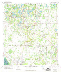
~ Citrus Park FL topo map, 1:24000 scale, 7.5 X 7.5 Minute, Historical, 1956, updated 1969
Citrus Park, Florida, USGS topographic map dated 1956.
Includes geographic coordinates (latitude and longitude). This topographic map is suitable for hiking, camping, and exploring, or framing it as a wall map.
Printed on-demand using high resolution imagery, on heavy weight and acid free paper, or alternatively on a variety of synthetic materials.
Topos available on paper, Waterproof, Poly, or Tyvek. Usually shipping rolled, unless combined with other folded maps in one order.
- Product Number: USGS-5622976
- Free digital map download (high-resolution, GeoPDF): Citrus Park, Florida (file size: 10 MB)
- Map Size: please refer to the dimensions of the GeoPDF map above
- Weight (paper map): ca. 55 grams
- Map Type: POD USGS Topographic Map
- Map Series: HTMC
- Map Verison: Historical
- Cell ID: 8828
- Scan ID: 345521
- Imprint Year: 1969
- Woodland Tint: Yes
- Aerial Photo Year: 1954
- Survey Year: 1956
- Datum: NAD27
- Map Projection: Polyconic
- Map published by United States Geological Survey
- Map Language: English
- Scanner Resolution: 600 dpi
- Map Cell Name: Citrus Park
- Grid size: 7.5 X 7.5 Minute
- Date on map: 1956
- Map Scale: 1:24000
- Geographical region: Florida, United States
Neighboring Maps:
All neighboring USGS topo maps are available for sale online at a variety of scales.
Spatial coverage:
Topo map Citrus Park, Florida, covers the geographical area associated the following places:
- Greenbrook Village - George Road Estates - Treehouses at Mohr Loop - The Landings of Tampa - Top of the Village - Westridge Village - Country Place - Mullins Manor - Village Estates - Huntington of Carrollwood - Waterfront Cove - Carrollwood West - Half Moon Lake Estates - Indian Lakes - West Park - Carrollwood Preserve - Turtle Creek - Carrollwood Village - Stonegate - Springwood Village - Quail Ridge North - West Park Estates - Cypress Run - Shays Crest - Belle Glen - The Cloister - Kirkland Acres - Dolce Vita - Pebblebrook - Bayport West - Levinson - Galleria - Cypress Glen - Stasia - Le Clare Estates - Catherine Park - Cypress Tree - Brookgreen Village - Westmont Oaks - Meadow Brook - Casey Lake Manors - The Paddocks at Van Dyke Farms - Hidden Lake - Essex Downs - Woods of Eden Rock - Quail Ridge - Brentwood - Frenchs - Twelve Oaks Village - Woodmont - Windsor Place at Citrus Park - West Bay - Whispering Oaks - Spivey - Estates of Rock Lake - Carrollwood Crossing - Citrus Park Commons - Miralago Estates - Four Score Manor - Copperfield - Carrollwood Springs - Reserve on Rock Lake - Tree Tops North - Timberlane - Chadbourne Village - Brentwood Park - Hampton Park - Ehrlich Gardenlands - Lake Maurine - Stoneleigh - Rawls Road - Villa Largo - Waterstone - Mandarin Lakes - Pretty Lake Estates - Northlake Village - Meadowglen - Sunray Estates - Floraland Acres - Lake Josephine Estates - Pine Terrace - Citrus Park - Idle Forest - Lowell Village - Keystone Groves - Oak View Terrace - Town 'n' Country - Sunshine Village - Villas of Northdale - Berkford Place - Burnbrook - Woodbriar West - Turner Trace - Longboat Landing - Pat Acres - Northbridge at Lake Pretty - Steeplechase - Andover - Wingate Village - Berkeley Square
- Map Area ID: AREA28.12528-82.625-82.5
- Northwest corner Lat/Long code: USGSNW28.125-82.625
- Northeast corner Lat/Long code: USGSNE28.125-82.5
- Southwest corner Lat/Long code: USGSSW28-82.625
- Southeast corner Lat/Long code: USGSSE28-82.5
- Northern map edge Latitude: 28.125
- Southern map edge Latitude: 28
- Western map edge Longitude: -82.625
- Eastern map edge Longitude: -82.5


