
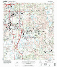
~ Brandon FL topo map, 1:24000 scale, 7.5 X 7.5 Minute, Historical, 1999, updated 2002
Brandon, Florida, USGS topographic map dated 1999.
Includes geographic coordinates (latitude and longitude). This topographic map is suitable for hiking, camping, and exploring, or framing it as a wall map.
Printed on-demand using high resolution imagery, on heavy weight and acid free paper, or alternatively on a variety of synthetic materials.
Topos available on paper, Waterproof, Poly, or Tyvek. Usually shipping rolled, unless combined with other folded maps in one order.
- Product Number: USGS-5622536
- Free digital map download (high-resolution, GeoPDF): Brandon, Florida (file size: 13 MB)
- Map Size: please refer to the dimensions of the GeoPDF map above
- Weight (paper map): ca. 55 grams
- Map Type: POD USGS Topographic Map
- Map Series: HTMC
- Map Verison: Historical
- Cell ID: 5263
- Scan ID: 345294
- Imprint Year: 2002
- Woodland Tint: Yes
- Survey Year: 1956
- Datum: NAD83
- Map Projection: Universal Transverse Mercator
- Map published by United States Geological Survey
- Map Language: English
- Scanner Resolution: 600 dpi
- Map Cell Name: Brandon
- Grid size: 7.5 X 7.5 Minute
- Date on map: 1999
- Map Scale: 1:24000
- Geographical region: Florida, United States
Neighboring Maps:
All neighboring USGS topo maps are available for sale online at a variety of scales.
Spatial coverage:
Topo map Brandon, Florida, covers the geographical area associated the following places:
- Brandon Mobile Villa - Lakewood Crest - Scanlon Country Estates - Mango Terrace - Tangelo - Tampa Terrace - Dixons - Brandon Crossroads - Minnie Villas - Progress Village - Faulkenburg Heights - Meadow Ridge Estates - Oak Landing - Greenfield Terrace - Leitners - Anselmi Acres - Amaya Estates - Brandon Lakes - Brandon Village - Orange Grove Estates - Lavity - Rolling Oaks - Rolling Acres - Fishers Farms - Jordan Oaks - Stonewood - Kingstowne Place - Boulevard Villas - Taylor Bay Estates - Alafia Estates - Hillsborough Avenue Farms - Ridge Court - Carriage Crossing - Brandon Mobile Estates - Shady Hollow - Colony Hill Estates - The Estates at Bloomingdale - Fields Park Place - Brandon Lakewood Estates - Brandon Brook Plaza - Hidden Forest - Valrico Lake - Timber Creek - Sanson Park - Allendale - Watermill at Providence Lakes - Southern Oaks Grove - Morrill Meadows - Highland Manor - Big Pines - Lake June Estates - Bryan Oaks Reserve - Hillside Manor - Parsons Reserve - Raven Oaks - South Ridge - Buffalo Avenue Farms - Clair-Mel City - Hollington Oaks - Williams Crossing - Brandon Spanish Oaks - Lake Marie Mobile Estates - Timber Knoll - Kingsway Gardens - Grove Park - Delaney Creek Estates - Happy Acres - Lakeview Village - Gold Coast - Mango Groves - Wildwood Hollow - Kingswood Heights - Dillon Acres - Wexford Green - Oakwood Heights - Sisson Heights - Kings Forest - Woodmere Heights - Shadow Bay - Limona - Canterbury Lakes - Brandon Woodlands - Tanglewood - Southwood Hills - Winchester Woods - Hickory Hammock - Valrico Woodland - Stevens Manor - Peppermill at Providence Lakes - Oakwood Ravine - Oak Valley - Oakridge Manor - Krebs - Lake Shore Ranch - Lakemont Hills - Hickory Highlands - Knifke Estates - Winston Manor - Breezy Meadows - Eureka Homes
- Map Area ID: AREA2827.875-82.375-82.25
- Northwest corner Lat/Long code: USGSNW28-82.375
- Northeast corner Lat/Long code: USGSNE28-82.25
- Southwest corner Lat/Long code: USGSSW27.875-82.375
- Southeast corner Lat/Long code: USGSSE27.875-82.25
- Northern map edge Latitude: 28
- Southern map edge Latitude: 27.875
- Western map edge Longitude: -82.375
- Eastern map edge Longitude: -82.25


