
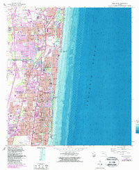
~ Boca Raton FL topo map, 1:24000 scale, 7.5 X 7.5 Minute, Historical, 1962, updated 1987
Boca Raton, Florida, USGS topographic map dated 1962.
Includes geographic coordinates (latitude and longitude). This topographic map is suitable for hiking, camping, and exploring, or framing it as a wall map.
Printed on-demand using high resolution imagery, on heavy weight and acid free paper, or alternatively on a variety of synthetic materials.
Topos available on paper, Waterproof, Poly, or Tyvek. Usually shipping rolled, unless combined with other folded maps in one order.
- Product Number: USGS-5622418
- Free digital map download (high-resolution, GeoPDF): Boca Raton, Florida (file size: 21 MB)
- Map Size: please refer to the dimensions of the GeoPDF map above
- Weight (paper map): ca. 55 grams
- Map Type: POD USGS Topographic Map
- Map Series: HTMC
- Map Verison: Historical
- Cell ID: 4653
- Scan ID: 345230
- Imprint Year: 1987
- Woodland Tint: Yes
- Photo Revision Year: 1983
- Aerial Photo Year: 1980
- Edit Year: 1983
- Field Check Year: 1962
- Survey Year: 1946
- Datum: NAD27
- Map Projection: Polyconic
- Map published by United States Geological Survey
- Map published by United States Department of Commerce
- Map Language: English
- Scanner Resolution: 600 dpi
- Map Cell Name: Boca Raton
- Grid size: 7.5 X 7.5 Minute
- Date on map: 1962
- Map Scale: 1:24000
- Geographical region: Florida, United States
Neighboring Maps:
All neighboring USGS topo maps are available for sale online at a variety of scales.
Spatial coverage:
Topo map Boca Raton, Florida, covers the geographical area associated the following places:
- Arlington Park - Coral Villas - Highland Woods Mobile Home Park - Boca Raton - College Park - Floresta - El Patio Mobile Home Park - Bali Hi Mobile Home Court - Cresthaven - Eastway Park - Ocean Vue - Royal Oak Hills - Broward Highlands - Tedder - Pompano Estates - Grubstake Trailer Park - Little Harbor on the Hillsboro - Collier Manor - Fairlawn - Kendall Green - Lighthouse Point - North Pompano Beach - Coral Manor - Pompano Beach Highlands - Hillsboro Beach - Shorewood - Deerfield Trailer Park - The Cove - Pine Tree Mobile Home Park - Highland Village Mobile Home Park - Carver Heights - Floresta Estates - Park Haven - Barwal - Breezy Hill Mobile Home Park - Havenwood Mobile Home Community - Deerfield Beach
- Map Area ID: AREA26.37526.25-80.125-80
- Northwest corner Lat/Long code: USGSNW26.375-80.125
- Northeast corner Lat/Long code: USGSNE26.375-80
- Southwest corner Lat/Long code: USGSSW26.25-80.125
- Southeast corner Lat/Long code: USGSSE26.25-80
- Northern map edge Latitude: 26.375
- Southern map edge Latitude: 26.25
- Western map edge Longitude: -80.125
- Eastern map edge Longitude: -80


