
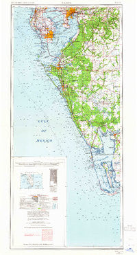
~ Tampa FL topo map, 1:250000 scale, 2 X 1 Degree, Historical, 1956, updated 1964
Tampa, Florida, USGS topographic map dated 1956.
Includes geographic coordinates (latitude and longitude). This topographic map is suitable for hiking, camping, and exploring, or framing it as a wall map.
Printed on-demand using high resolution imagery, on heavy weight and acid free paper, or alternatively on a variety of synthetic materials.
Topos available on paper, Waterproof, Poly, or Tyvek. Usually shipping rolled, unless combined with other folded maps in one order.
- Product Number: USGS-5621816
- Free digital map download (high-resolution, GeoPDF): Tampa, Florida (file size: 11 MB)
- Map Size: please refer to the dimensions of the GeoPDF map above
- Weight (paper map): ca. 55 grams
- Map Type: POD USGS Topographic Map
- Map Series: HTMC
- Map Verison: Historical
- Cell ID: 320751
- Scan ID: 348789
- Imprint Year: 1964
- Woodland Tint: Yes
- Edit Year: 1964
- Field Check Year: 1956
- Datum: Unstated
- Map Projection: Transverse Mercator
- Map published by United States Geological Survey
- Map Language: English
- Scanner Resolution: 600 dpi
- Map Cell Name: Tampa
- Grid size: 2 X 1 Degree
- Date on map: 1956
- Map Scale: 1:250000
- Geographical region: Florida, United States
Neighboring Maps:
All neighboring USGS topo maps are available for sale online at a variety of scales.
Spatial coverage:
Topo map Tampa, Florida, covers the geographical area associated the following places:
- Corbett Acres - Kingswood Heights - East View - Triangle Heights - D And E Acres - Beacon Hill - Oaklan - Van Diver Place - Easy Way - Grenelle Gardens - Belle Timbre - The Estates at Bayshore Pointe - Garden City - Woodland Acres - Arlington Heights West - Palm - Harbourside at Harbour Island - Grand View - Creekside Acres - West Shore Crest - Keebler - Post Harbour Island - Green Acres - Larrie Ellen Park - Maxwellton - Scheurer - Cape Haze - Peeples Acres - Oakbriar - Tampa Tourist Club - Morris Park Farms - Eldra - Zambito - Melouga Preserve - Kayla Ranch - Turleys - Brandon Brook Plaza - Boca Grande - South Trail - Terra Nova - Kings Forest - Shawnee Hills - Central Village - East Bay Farms - Ballentine Manor - Canter - Golfwood Estates - Hellekes - Louis Place - White Beach - Bayshore West - Sparkman Oaks - Morales Grove Park - Grant Park - Bingham - Balm - Marie - Little Oak Estates - Matoaka - Hollington Oaks - Emma Heights - Varn Park - Broadway - Les Jardins de Floride - Westwego - Meadowbrooke at Summerfield - Sunnyland - Wetherington Oaks - Jordan Oaks - Eagle Watch - Waugh - Island Homes - Hurley Manor - Brians Pond - Cones - Ruffin Acres - Wheeler Groves - Magnolia Beach - Alderman - Dovewood Estates - Pine Grove Reserve - Tagliarini - Hesperides - Covington Park - Hillcrest - Canterbury Oaks - South Plant City Farms - Miakka - Sun Lakes - Wellington South at Bay Park - Cristina - Alexus Estates - Funks Home Park - North Bon Air - Countryside Manor - Key West Landings - Wells - Barnhart - Beulah - Fishers
- Map Area ID: AREA2826-83-82
- Northwest corner Lat/Long code: USGSNW28-83
- Northeast corner Lat/Long code: USGSNE28-82
- Southwest corner Lat/Long code: USGSSW26-83
- Southeast corner Lat/Long code: USGSSE26-82
- Northern map edge Latitude: 28
- Southern map edge Latitude: 26
- Western map edge Longitude: -83
- Eastern map edge Longitude: -82


