
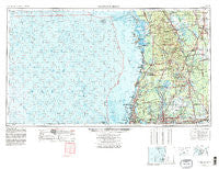
~ Tarpon Springs FL topo map, 1:250000 scale, 1 X 2 Degree, Historical, 1955, updated 1978
Tarpon Springs, Florida, USGS topographic map dated 1955.
Includes geographic coordinates (latitude and longitude). This topographic map is suitable for hiking, camping, and exploring, or framing it as a wall map.
Printed on-demand using high resolution imagery, on heavy weight and acid free paper, or alternatively on a variety of synthetic materials.
Topos available on paper, Waterproof, Poly, or Tyvek. Usually shipping rolled, unless combined with other folded maps in one order.
- Product Number: USGS-5621796
- Free digital map download (high-resolution, GeoPDF): Tarpon Springs, Florida (file size: 21 MB)
- Map Size: please refer to the dimensions of the GeoPDF map above
- Weight (paper map): ca. 55 grams
- Map Type: POD USGS Topographic Map
- Map Series: HTMC
- Map Verison: Historical
- Cell ID: 69047
- Scan ID: 348804
- Imprint Year: 1978
- Woodland Tint: Yes
- Visual Version Number: 2
- Aerial Photo Year: 1974
- Edit Year: 1977
- Field Check Year: 1955
- Datum: Unstated
- Map Projection: Transverse Mercator
- Map published by United States Geological Survey
- Map Language: English
- Scanner Resolution: 600 dpi
- Map Cell Name: Tarpon Springs
- Grid size: 1 X 2 Degree
- Date on map: 1955
- Map Scale: 1:250000
- Geographical region: Florida, United States
Neighboring Maps:
All neighboring USGS topo maps are available for sale online at a variety of scales.
Spatial coverage:
Topo map Tarpon Springs, Florida, covers the geographical area associated the following places:
- Cousins Corner - Hernando Beach - Bella Vista Mobile Home Park - Bella Farms - Lakes of Wellington - Norris - Americana - Estates of Lake Alice - Villa Largo - Alldredge - Lakewood Manor - Pointe at Tampa Palms - Forest Oak - Lipsey - Martha Ann Trailer Village - Oxford - Stasia - Sylvia - Rainforest East - Todd Acres - Pippin Acres - Hillcrest Acres - Lake Pointe - Villa Questol - Rerdell - Country Oaks - Suydam - Cathcarts Square - Hammocks - Highland Pines Estates - Arrand Heights - Harvey Heights - Lake Lindsey - Northwest Park - Rosa Woods - Burchwood - Carrollwood Oaks - Cypress Reserve - Forbes Acres - Villas of San Marino at Carrollwood - The Manors at White Trout Lake - Kathleen - Temple Terrace Heights - Wilder Park - Lake Brooker South - Cross Creek Gardens - Lake View Heights - Cedar Cove - Cypress Cove - Kenny - Loyce - Morningside Heights - Lake Thomas Estates - Alderman - Northwood Village - Hammock Woods - Wahoo - Fivacres - Poinsettia Place - Northbridge at Lake Pretty - Maxwell Acres - Puritan Heights - Kinard Estates - The Oaks at Busch - Floravilla - Koostra - Tilsen Manor - Lone Pine - Michaelangelo - Lake Carroll Manor - Bushnell Trailer Court - Turning Point - Lee Villa - Hollyglen Village - Carriage Hills - Newport Gardens - Four Seasons - Temple Terrace Woods - Jurnigan Acres - Idlewild on the Hillsborough - Pinehurst Park - Pinker - Willow Creek - Hunters Run - Villa Roma - Masaryktown - Citrus Park Crossing - Lake Forest - Dunwoodie Park - Roseland Park - Wildes Pond - Hazen Court - Norma Lee Heights - Richmond Place - Silver Bluff Estates - Clo Mar Homes - Chapmans Mobile Home Park - Lake View Park - Temple Terrace Gardens - Heather Manor
- Map Area ID: AREA2928-84-82
- Northwest corner Lat/Long code: USGSNW29-84
- Northeast corner Lat/Long code: USGSNE29-82
- Southwest corner Lat/Long code: USGSSW28-84
- Southeast corner Lat/Long code: USGSSE28-82
- Northern map edge Latitude: 29
- Southern map edge Latitude: 28
- Western map edge Longitude: -84
- Eastern map edge Longitude: -82


