
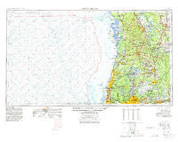
~ Tarpon Springs FL topo map, 1:250000 scale, 1 X 2 Degree, Historical, 1955, updated 1978
Tarpon Springs, Florida, USGS topographic map dated 1955.
Includes geographic coordinates (latitude and longitude). This topographic map is suitable for hiking, camping, and exploring, or framing it as a wall map.
Printed on-demand using high resolution imagery, on heavy weight and acid free paper, or alternatively on a variety of synthetic materials.
Topos available on paper, Waterproof, Poly, or Tyvek. Usually shipping rolled, unless combined with other folded maps in one order.
- Product Number: USGS-5621794
- Free digital map download (high-resolution, GeoPDF): Tarpon Springs, Florida (file size: 15 MB)
- Map Size: please refer to the dimensions of the GeoPDF map above
- Weight (paper map): ca. 55 grams
- Map Type: POD USGS Topographic Map
- Map Series: HTMC
- Map Verison: Historical
- Cell ID: 69047
- Scan ID: 348803
- Imprint Year: 1978
- Woodland Tint: Yes
- Aerial Photo Year: 1974
- Edit Year: 1977
- Field Check Year: 1955
- Datum: Unstated
- Map Projection: Transverse Mercator
- Map published by United States Geological Survey
- Map Language: English
- Scanner Resolution: 600 dpi
- Map Cell Name: Tarpon Springs
- Grid size: 1 X 2 Degree
- Date on map: 1955
- Map Scale: 1:250000
- Geographical region: Florida, United States
Neighboring Maps:
All neighboring USGS topo maps are available for sale online at a variety of scales.
Spatial coverage:
Topo map Tarpon Springs, Florida, covers the geographical area associated the following places:
- River Run - Great Lakes - Rosemont - Hamilton Park - Silver Forrest - Carrillon Estates - Barbara Heights - Fivacres - Oak Dale Heights - Northbridge at Lake Pretty - Druid Hills - Chadbourne Village - Brightside Village - Croom - Orangewood Manor - Homosassa - Morningside Heights - Nelms - Clinton Heights - Washington Park - McElveen - Kings Village - Villa Largo - Deer Park - Chukuchatta (historical) - Sweats - Florida Avenue - Cypress Lakes Golf and Country Club Mobile Home Park - Sawyers Heavenbound Estates - Strickland - Weeki Wachee Gardens - Turnberry at the Eagles - Bougainvillea Oaks - Woodacre Estates of Northdale - Shelleys Corner - Ziegler Brothers Estates - Balincort Heights - Vine Park - Lorraine Estates - Sapphire Lake - Cypress Hollow - Horn Acres - Armenia Court - College Village - Lakewood Place - Cheval Boulevard Estates West - Westridge Village - Green Valley - Rosa Acres - The Oaks - Forest Hills - Lake Calm - Cumberland Manors - Hampton on the Green - Evanell Estates - Carrollwood Estates - River Haven Estates - Valmar - Appling Woods - Temple Terrace Hills - Brenmar Acres - Burnbrook - Mecca - Badgers Lair - Rainbow Terrace - Weeki Wachee Acres - Enclave of Carrollwood - Bellingham Oaks - Beacon Meadows - Crestmont - Lake Morley Terrace Estates - University Village - Clubview - Suns Acres - Van Dyke Estates - Heather Manor - Parsons Pointe - Hickory Hill - Reynoldswood - Temple Terrace Plaza - Madison Park West - San Juan Acres - Dallas - Spivey Acres - Linda Diane - Orange Heights West - Land O' Lakes - Victor - Belle Meade - Pasadena Shores - Terrell - Vista Ridge - Estelle Estates - Log Cabin Hills - New Port Richey - Barrington - Sugarwood Grove - Avery Oaks - Lake Brooker Village - Pineola
- Map Area ID: AREA2928-84-82
- Northwest corner Lat/Long code: USGSNW29-84
- Northeast corner Lat/Long code: USGSNE29-82
- Southwest corner Lat/Long code: USGSSW28-84
- Southeast corner Lat/Long code: USGSSE28-82
- Northern map edge Latitude: 29
- Southern map edge Latitude: 28
- Western map edge Longitude: -84
- Eastern map edge Longitude: -82


